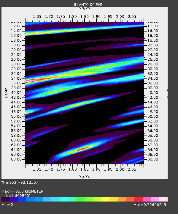
ANTO Ankara, Turkey - Earthquake Result Viewer
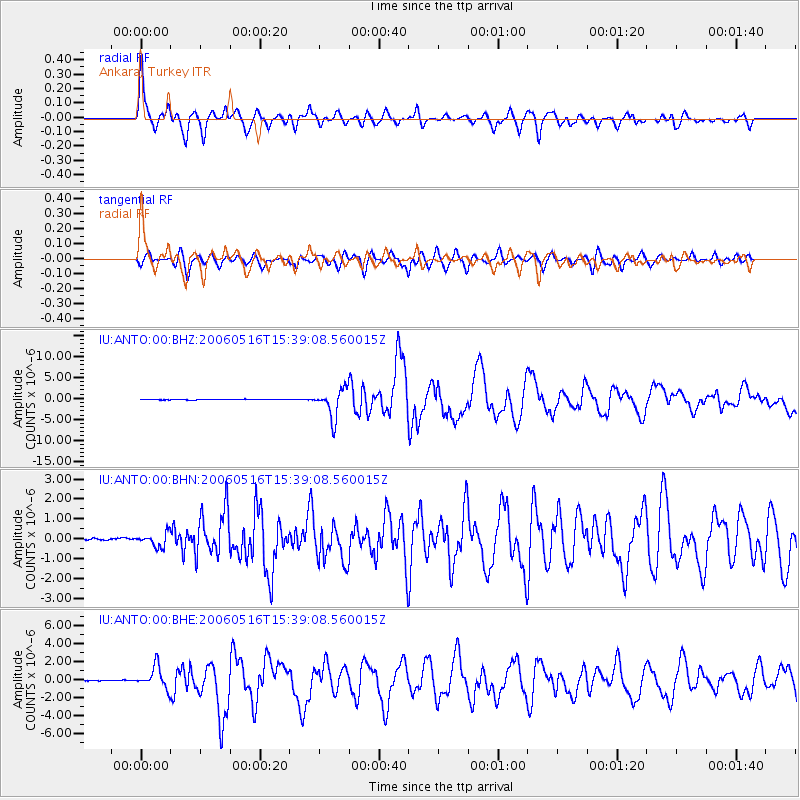
Earthquake location: Northern Sumatra, Indonesia
Earthquake latitude/longitude: 0.1/97.1
Earthquake time(UTC): 2006/05/16 (136) 15:28:25 GMT
Earthquake Depth: 12 km
Earthquake Magnitude: 6.6 MB, 6.8 MS, 6.8 MW, 6.8 MW
Earthquake Catalog/Contributor: WHDF/NEIC
Network: IU Global Seismograph Network (GSN - IRIS/USGS)
Station: ANTO Ankara, Turkey
Lat/Lon: 39.87 N/32.79 E
Elevation: 883 m
Distance: 70.4 deg
Az: 312.622 deg
Baz: 107.041 deg
Ray Param: 0.054998536
Estimated Moho Depth: 35.0 km
Estimated Crust Vp/Vs: 1.60
Assumed Crust Vp: 6.159 km/s
Estimated Crust Vs: 3.843 km/s
Estimated Crust Poisson's Ratio: 0.18
Radial Match: 92.12107 %
Radial Bump: 400
Transverse Match: 79.143 %
Transverse Bump: 400
SOD ConfigId: 2669
Insert Time: 2010-03-03 14:08:49.497 +0000
GWidth: 2.5
Max Bumps: 400
Tol: 0.001

Signal To Noise

ChannelStoNSTALTA
IU:ANTO:00:BHN:20060516T15:39:08.560015Z3.1340443.4615212E-71.1044903E-7
IU:ANTO:00:BHE:20060516T15:39:08.560015Z18.8110851.245462E-66.620894E-8
IU:ANTO:00:BHZ:20060516T15:39:08.560015Z54.710743.4152665E-66.2424064E-8
Arrivals
Ps3.6 SECOND
PpPs14 SECOND
PsPs/PpSs18 SECOND