You are here: Home > Network List > TA - USArray Transportable Network (new EarthScope stations) Stations List
> Station I23K Minto, Yukon-Koyukuk, AK, USA > Earthquake Result Viewer
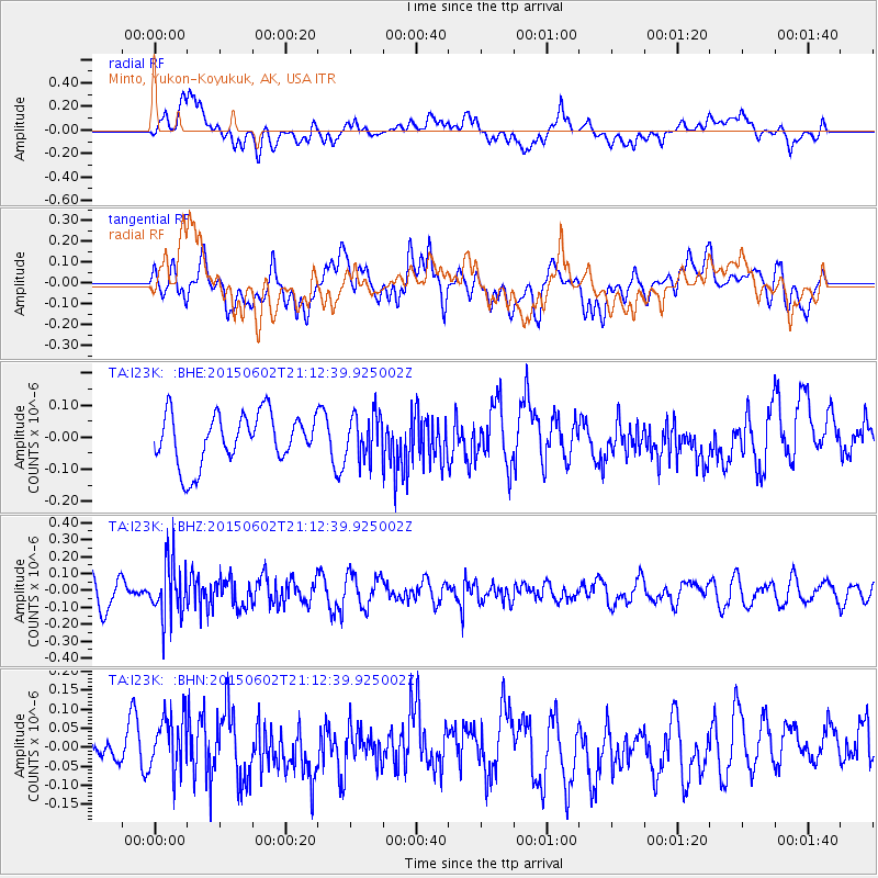
I23K Minto, Yukon-Koyukuk, AK, USA - Earthquake Result Viewer
*The percent match for this event was below the threshold and hence no stack was calculated.
| Earthquake location: |
Bonin Islands, Japan Region |
| Earthquake latitude/longitude: |
27.9/140.6 |
| Earthquake time(UTC): |
2015/06/02 (153) 21:04:28 GMT |
| Earthquake Depth: |
687 km |
| Earthquake Magnitude: |
4.9 mb |
| Earthquake Catalog/Contributor: |
ISC/ISC |
|
| Network: |
TA USArray Transportable Network (new EarthScope stations) |
| Station: |
I23K Minto, Yukon-Koyukuk, AK, USA |
| Lat/Lon: |
65.15 N/149.36 W |
| Elevation: |
149 m |
|
| Distance: |
56.7 deg |
| Az: |
28.376 deg |
| Baz: |
264.686 deg |
| Ray Param: |
$rayparam |
*The percent match for this event was below the threshold and hence was not used in the summary stack. |
|
| Radial Match: |
42.794132 % |
| Radial Bump: |
400 |
| Transverse Match: |
51.40833 % |
| Transverse Bump: |
400 |
| SOD ConfigId: |
7422571 |
| Insert Time: |
2019-04-19 05:02:47.937 +0000 |
| GWidth: |
2.5 |
| Max Bumps: |
400 |
| Tol: |
0.001 |
|
Signal To Noise
| Channel | StoN | STA | LTA |
| TA:I23K: :BHZ:20150602T21:12:39.925002Z | 1.6937301 | 1.5634774E-7 | 9.230971E-8 |
| TA:I23K: :BHN:20150602T21:12:39.925002Z | 1.0539817 | 7.6347696E-8 | 7.24374E-8 |
| TA:I23K: :BHE:20150602T21:12:39.925002Z | 0.8916821 | 7.0131144E-8 | 7.865039E-8 |
| Arrivals |
| Ps | |
| PpPs | |
| PsPs/PpSs | |


