You are here: Home > Network List > IU - Global Seismograph Network (GSN - IRIS/USGS) Stations List
> Station ANTO Ankara, Turkey > Earthquake Result Viewer
ANTO Ankara, Turkey - Earthquake Result Viewer
| Earthquake location: |
Mid-Indian Ridge |
| Earthquake latitude/longitude: |
-36.8/78.5 |
| Earthquake time(UTC): |
2006/05/07 (127) 14:17:35 GMT |
| Earthquake Depth: |
10 km |
| Earthquake Magnitude: |
5.5 MB, 5.8 MS, 6.1 MW, 6.1 MW |
| Earthquake Catalog/Contributor: |
WHDF/NEIC |
|
| Network: |
IU Global Seismograph Network (GSN - IRIS/USGS) |
| Station: |
ANTO Ankara, Turkey |
| Lat/Lon: |
39.87 N/32.79 E |
| Elevation: |
883 m |
|
| Distance: |
87.1 deg |
| Az: |
326.496 deg |
| Baz: |
144.855 deg |
| Ray Param: |
0.043549255 |
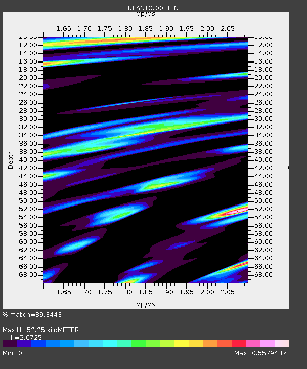
| Estimated Moho Depth: |
52.25 km |
| Estimated Crust Vp/Vs: |
2.07 |
| Assumed Crust Vp: |
6.159 km/s |
| Estimated Crust Vs: |
2.972 km/s |
| Estimated Crust Poisson's Ratio: |
0.35 |
|
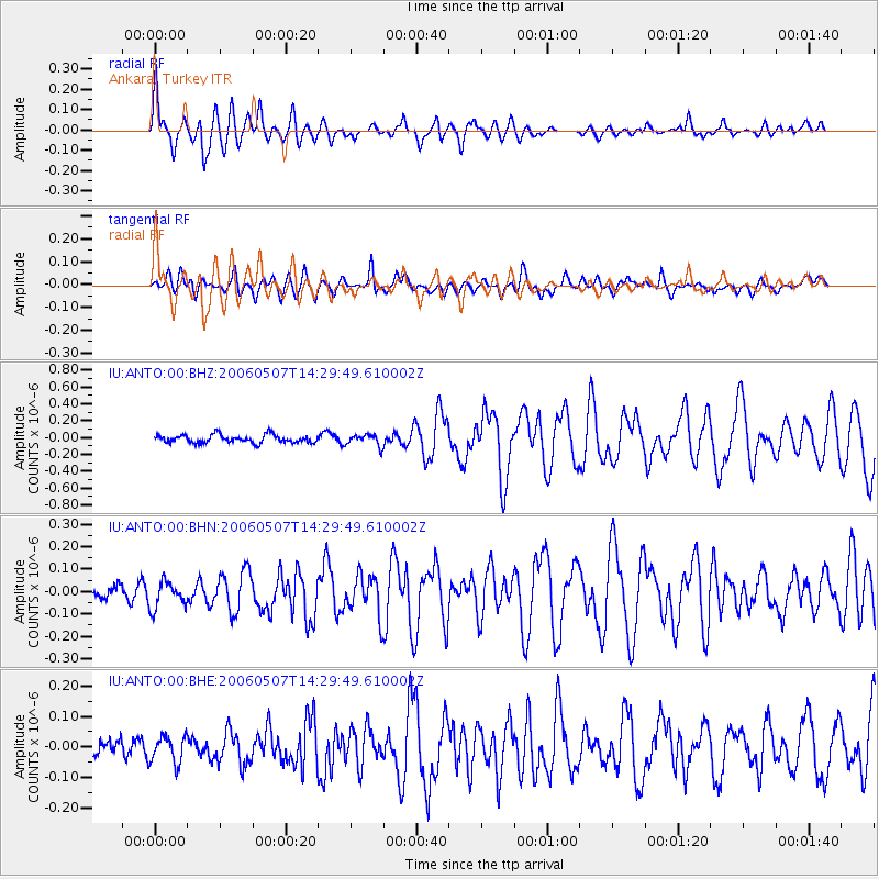
| Radial Match: |
89.3443 % |
| Radial Bump: |
400 |
| Transverse Match: |
71.85313 % |
| Transverse Bump: |
400 |
| SOD ConfigId: |
2669 |
| Insert Time: |
2010-03-03 14:08:52.712 +0000 |
| GWidth: |
2.5 |
| Max Bumps: |
400 |
| Tol: |
0.001 |
|
Signal To Noise
| Channel | StoN | STA | LTA |
| IU:ANTO:00:BHN:20060507T14:29:49.610002Z | 2.221101 | 5.9092955E-8 | 2.6605251E-8 |
| IU:ANTO:00:BHE:20060507T14:29:49.610002Z | 1.5233413 | 4.427778E-8 | 2.9066223E-8 |
| IU:ANTO:00:BHZ:20060507T14:29:49.610002Z | 1.4795336 | 6.9868214E-8 | 4.7223136E-8 |
| Arrivals |
| Ps | 9.3 SECOND |
| PpPs | 26 SECOND |
| PsPs/PpSs | 35 SECOND |


