You are here: Home > Network List > IU - Global Seismograph Network (GSN - IRIS/USGS) Stations List
> Station ANTO Ankara, Turkey > Earthquake Result Viewer
ANTO Ankara, Turkey - Earthquake Result Viewer
| Earthquake location: |
Hokkaido, Japan Region |
| Earthquake latitude/longitude: |
41.9/144.8 |
| Earthquake time(UTC): |
1997/10/08 (281) 21:20:59 GMT |
| Earthquake Depth: |
33 km |
| Earthquake Magnitude: |
5.5 MB, 5.6 MS, 5.9 UNKNOWN, 5.9 MW |
| Earthquake Catalog/Contributor: |
WHDF/NEIC |
|
| Network: |
IU Global Seismograph Network (GSN - IRIS/USGS) |
| Station: |
ANTO Ankara, Turkey |
| Lat/Lon: |
39.87 N/32.79 E |
| Elevation: |
883 m |
|
| Distance: |
77.9 deg |
| Az: |
313.141 deg |
| Baz: |
45.045 deg |
| Ray Param: |
0.04995769 |
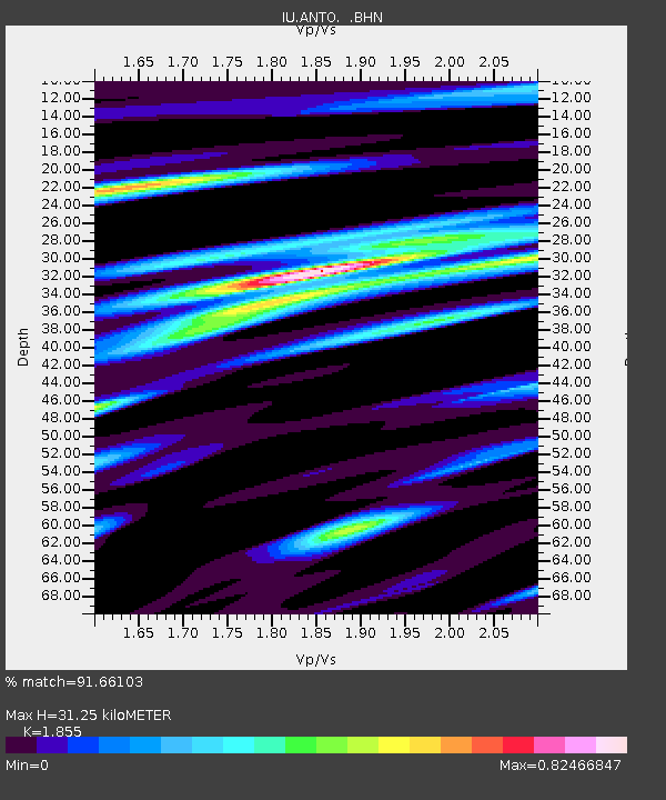
| Estimated Moho Depth: |
31.25 km |
| Estimated Crust Vp/Vs: |
1.86 |
| Assumed Crust Vp: |
6.159 km/s |
| Estimated Crust Vs: |
3.32 km/s |
| Estimated Crust Poisson's Ratio: |
0.30 |
|
| Radial Match: |
91.66103 % |
| Radial Bump: |
400 |
| Transverse Match: |
81.33731 % |
| Transverse Bump: |
400 |
| SOD ConfigId: |
4480 |
| Insert Time: |
2010-03-03 14:09:19.783 +0000 |
| GWidth: |
2.5 |
| Max Bumps: |
400 |
| Tol: |
0.001 |
|

Signal To Noise
| Channel | StoN | STA | LTA |
| IU:ANTO: :BHN:19971008T21:32:23.140002Z | 12.347102 | 6.178524E-7 | 5.0040274E-8 |
| IU:ANTO: :BHE:19971008T21:32:23.140002Z | 3.518993 | 1.7764117E-7 | 5.0480683E-8 |
| IU:ANTO: :BHZ:19971008T21:32:23.140002Z | 5.152586 | 1.603124E-7 | 3.1113E-8 |
| Arrivals |
| Ps | 4.5 SECOND |
| PpPs | 14 SECOND |
| PsPs/PpSs | 19 SECOND |


