You are here: Home > Network List > AV - Alaska Volcano Observatory Stations List
> Station AMKA Regional Station, Amchitka Island, Alaska > Earthquake Result Viewer
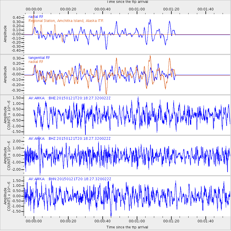
AMKA Regional Station, Amchitka Island, Alaska - Earthquake Result Viewer
*The percent match for this event was below the threshold and hence no stack was calculated.
| Earthquake location: |
Eastern New Guinea Reg., P.N.G. |
| Earthquake latitude/longitude: |
-5.6/146.3 |
| Earthquake time(UTC): |
2015/01/21 (021) 20:08:33 GMT |
| Earthquake Depth: |
49 km |
| Earthquake Magnitude: |
5.7 MB |
| Earthquake Catalog/Contributor: |
NEIC PDE/NEIC COMCAT |
|
| Network: |
AV Alaska Volcano Observatory |
| Station: |
AMKA Regional Station, Amchitka Island, Alaska |
| Lat/Lon: |
51.38 N/179.30 E |
| Elevation: |
116 m |
|
| Distance: |
63.4 deg |
| Az: |
22.424 deg |
| Baz: |
217.281 deg |
| Ray Param: |
$rayparam |
*The percent match for this event was below the threshold and hence was not used in the summary stack. |
|
| Radial Match: |
52.173615 % |
| Radial Bump: |
400 |
| Transverse Match: |
39.700825 % |
| Transverse Bump: |
330 |
| SOD ConfigId: |
837871 |
| Insert Time: |
2015-02-04 20:26:11.479 +0000 |
| GWidth: |
2.5 |
| Max Bumps: |
400 |
| Tol: |
0.001 |
|
Signal To Noise
| Channel | StoN | STA | LTA |
| AV:AMKA: :BHZ:20150121T20:18:27.320022Z | 1.6284803 | 9.2626084E-7 | 5.687885E-7 |
| AV:AMKA: :BHN:20150121T20:18:27.320022Z | 1.2860702 | 6.4637953E-7 | 5.026005E-7 |
| AV:AMKA: :BHE:20150121T20:18:27.320022Z | 1.053735 | 5.64399E-7 | 5.356176E-7 |
| Arrivals |
| Ps | |
| PpPs | |
| PsPs/PpSs | |


