You are here: Home > Network List > CI - Caltech Regional Seismic Network Stations List
> Station OSI Osito Adit, California, USA > Earthquake Result Viewer
OSI Osito Adit, California, USA - Earthquake Result Viewer
| Earthquake location: |
Solomon Islands |
| Earthquake latitude/longitude: |
-7.3/155.7 |
| Earthquake time(UTC): |
2007/04/01 (091) 21:11:33 GMT |
| Earthquake Depth: |
10 km |
| Earthquake Magnitude: |
6.3 MB |
| Earthquake Catalog/Contributor: |
WHDF/NEIC |
|
| Network: |
CI Caltech Regional Seismic Network |
| Station: |
OSI Osito Adit, California, USA |
| Lat/Lon: |
34.61 N/118.72 W |
| Elevation: |
706 m |
|
| Distance: |
90.4 deg |
| Az: |
55.315 deg |
| Baz: |
261.497 deg |
| Ray Param: |
0.041672945 |
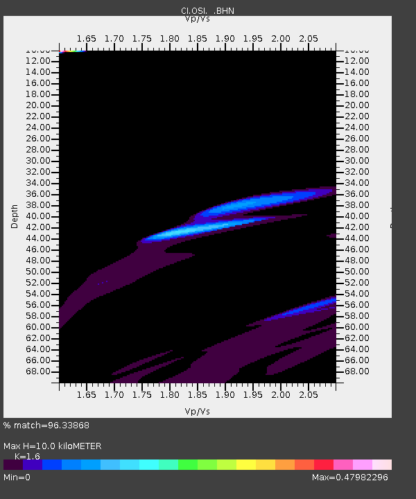
| Estimated Moho Depth: |
10.0 km |
| Estimated Crust Vp/Vs: |
1.60 |
| Assumed Crust Vp: |
6.1 km/s |
| Estimated Crust Vs: |
3.812 km/s |
| Estimated Crust Poisson's Ratio: |
0.18 |
|
| Radial Match: |
96.33868 % |
| Radial Bump: |
318 |
| Transverse Match: |
39.71011 % |
| Transverse Bump: |
340 |
| SOD ConfigId: |
2564 |
| Insert Time: |
2010-02-25 21:29:44.576 +0000 |
| GWidth: |
2.5 |
| Max Bumps: |
400 |
| Tol: |
0.001 |
|

Signal To Noise
| Channel | StoN | STA | LTA |
| CI:OSI: :BHN:20070401T21:24:03.217017Z | 2.4786026 | 6.6767156E-5 | 2.6937418E-5 |
| CI:OSI: :BHE:20070401T21:24:03.217017Z | 2.196678 | 6.0163755E-5 | 2.738852E-5 |
| CI:OSI: :BHZ:20070401T21:24:03.217017Z | 1.3802035 | 4.1041705E-5 | 2.9735982E-5 |
| Arrivals |
| Ps | 1.0 SECOND |
| PpPs | 4.2 SECOND |
| PsPs/PpSs | 5.2 SECOND |


