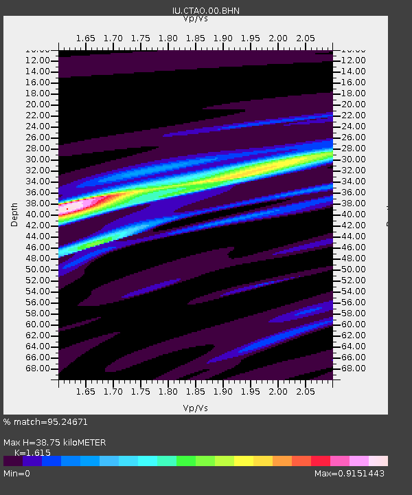
CTAO Charters Towers, Australia - Earthquake Result Viewer
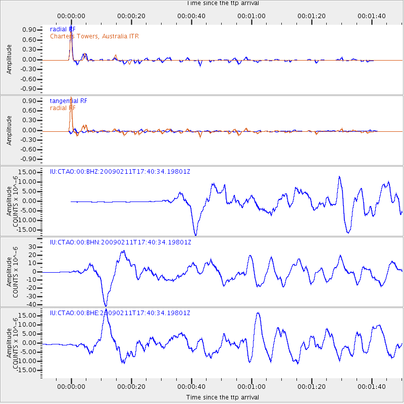
Earthquake location: Talaud Islands, Indonesia
Earthquake latitude/longitude: 3.9/126.4
Earthquake time(UTC): 2009/02/11 (042) 17:34:50 GMT
Earthquake Depth: 22 km
Earthquake Magnitude: 6.6 MB, 7.2 MS, 7.2 MW, 7.1 MW
Earthquake Catalog/Contributor: WHDF/NEIC
Network: IU Global Seismograph Network (GSN - IRIS/USGS)
Station: CTAO Charters Towers, Australia
Lat/Lon: 20.09 S/146.25 E
Elevation: 357 m
Distance: 30.8 deg
Az: 141.414 deg
Baz: 318.543 deg
Ray Param: 0.07922422
Estimated Moho Depth: 38.75 km
Estimated Crust Vp/Vs: 1.62
Assumed Crust Vp: 6.522 km/s
Estimated Crust Vs: 4.038 km/s
Estimated Crust Poisson's Ratio: 0.19
Radial Match: 95.24671 %
Radial Bump: 245
Transverse Match: 73.814026 %
Transverse Bump: 400
SOD ConfigId: 2658
Insert Time: 2010-03-03 14:11:41.479 +0000
GWidth: 2.5
Max Bumps: 400
Tol: 0.001

Signal To Noise

ChannelStoNSTALTA
IU:CTAO:00:BHN:20090211T17:40:34.19801Z10.14481.5182889E-61.4966179E-7
IU:CTAO:00:BHE:20090211T17:40:34.19801Z5.45766977.2669127E-71.3315046E-7
IU:CTAO:00:BHZ:20090211T17:40:34.19801Z8.1901187.7243675E-79.4313265E-8
Arrivals
Ps4.0 SECOND
PpPs14 SECOND
PsPs/PpSs18 SECOND