You are here: Home > Network List > TA - USArray Transportable Network (new EarthScope stations) Stations List
> Station H21K Melozitna River, AK, USA > Earthquake Result Viewer
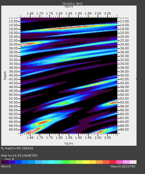
H21K Melozitna River, AK, USA - Earthquake Result Viewer
| Earthquake location: |
Borneo |
| Earthquake latitude/longitude: |
6.1/116.5 |
| Earthquake time(UTC): |
2015/06/04 (155) 23:15:43 GMT |
| Earthquake Depth: |
10 km |
| Earthquake Magnitude: |
6.0 MO |
| Earthquake Catalog/Contributor: |
NEIC PDE/NEIC ALERT |
|
| Network: |
TA USArray Transportable Network (new EarthScope stations) |
| Station: |
H21K Melozitna River, AK, USA |
| Lat/Lon: |
65.66 N/152.80 W |
| Elevation: |
520 m |
|
| Distance: |
84.8 deg |
| Az: |
24.595 deg |
| Baz: |
273.099 deg |
| Ray Param: |
0.045244925 |
| Estimated Moho Depth: |
24.25 km |
| Estimated Crust Vp/Vs: |
1.60 |
| Assumed Crust Vp: |
6.566 km/s |
| Estimated Crust Vs: |
4.104 km/s |
| Estimated Crust Poisson's Ratio: |
0.18 |
|
| Radial Match: |
85.359406 % |
| Radial Bump: |
393 |
| Transverse Match: |
85.076965 % |
| Transverse Bump: |
400 |
| SOD ConfigId: |
7422571 |
| Insert Time: |
2019-04-19 05:27:08.094 +0000 |
| GWidth: |
2.5 |
| Max Bumps: |
400 |
| Tol: |
0.001 |
|

Signal To Noise
| Channel | StoN | STA | LTA |
| TA:H21K: :BHZ:20150604T23:27:46.725Z | 7.534165 | 6.0837067E-7 | 8.074825E-8 |
| TA:H21K: :BHN:20150604T23:27:46.725Z | 0.9196275 | 8.889078E-8 | 9.6659555E-8 |
| TA:H21K: :BHE:20150604T23:27:46.725Z | 2.7798648 | 2.845156E-7 | 1.0234873E-7 |
| Arrivals |
| Ps | 2.3 SECOND |
| PpPs | 9.3 SECOND |
| PsPs/PpSs | 12 SECOND |


