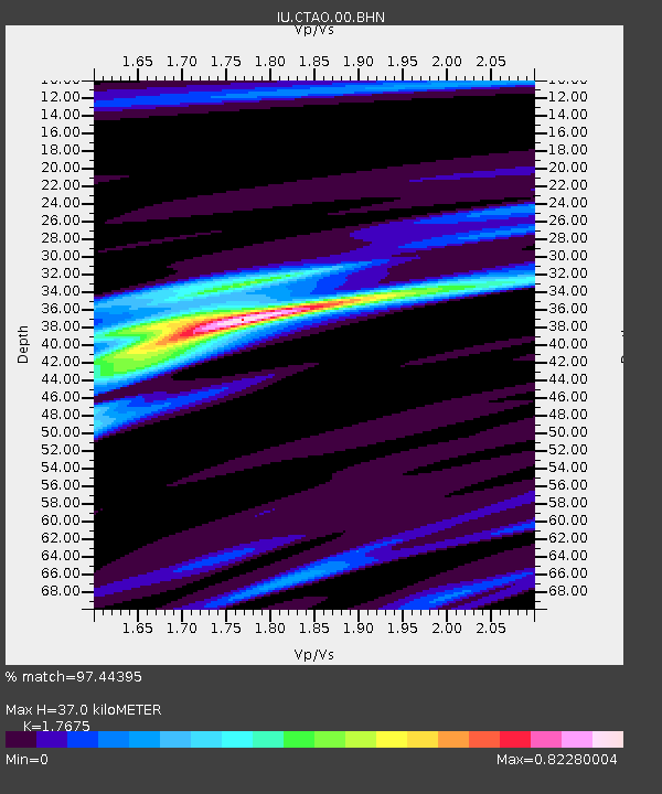
CTAO Charters Towers, Australia - Earthquake Result Viewer

Earthquake location: Southwestern Ryukyu Isl., Japan
Earthquake latitude/longitude: 23.3/124.1
Earthquake time(UTC): 2002/03/26 (085) 03:45:48 GMT
Earthquake Depth: 33 km
Earthquake Magnitude: 5.8 MB, 6.6 MS, 6.4 MW, 6.4 MW
Earthquake Catalog/Contributor: WHDF/NEIC
Network: IU Global Seismograph Network (GSN - IRIS/USGS)
Station: CTAO Charters Towers, Australia
Lat/Lon: 20.09 S/146.25 E
Elevation: 357 m
Distance: 48.3 deg
Az: 151.636 deg
Baz: 332.319 deg
Ray Param: 0.06939977
Estimated Moho Depth: 37.0 km
Estimated Crust Vp/Vs: 1.77
Assumed Crust Vp: 6.522 km/s
Estimated Crust Vs: 3.69 km/s
Estimated Crust Poisson's Ratio: 0.26
Radial Match: 97.44395 %
Radial Bump: 213
Transverse Match: 67.350945 %
Transverse Bump: 400
SOD ConfigId: 20082
Insert Time: 2010-03-03 14:12:01.210 +0000
GWidth: 2.5
Max Bumps: 400
Tol: 0.001

Signal To Noise

ChannelStoNSTALTA
IU:CTAO:00:BHN:20020326T03:53:56.072009Z15.21151.1853588E-67.792517E-8
IU:CTAO:00:BHE:20020326T03:53:56.072009Z5.5173896.2895975E-71.139959E-7
IU:CTAO:00:BHZ:20020326T03:53:56.072009Z16.1098672.5855015E-61.604918E-7
Arrivals
Ps4.6 SECOND
PpPs15 SECOND
PsPs/PpSs19 SECOND