You are here: Home > Network List > TA - USArray Transportable Network (new EarthScope stations) Stations List
> Station 121A Cookes Peak, Deming, NM, USA > Earthquake Result Viewer
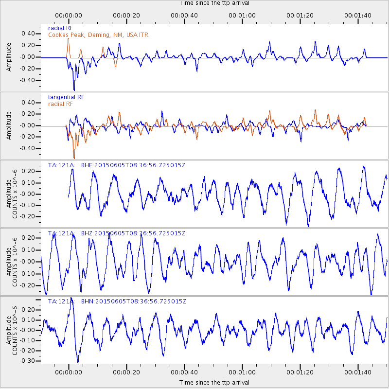
121A Cookes Peak, Deming, NM, USA - Earthquake Result Viewer
*The percent match for this event was below the threshold and hence no stack was calculated.
| Earthquake location: |
Kermadec Islands Region |
| Earthquake latitude/longitude: |
-28.9/-175.9 |
| Earthquake time(UTC): |
2015/06/05 (156) 08:24:33 GMT |
| Earthquake Depth: |
10 km |
| Earthquake Magnitude: |
4.9 MW |
| Earthquake Catalog/Contributor: |
ISC/ISC |
|
| Network: |
TA USArray Transportable Network (new EarthScope stations) |
| Station: |
121A Cookes Peak, Deming, NM, USA |
| Lat/Lon: |
32.53 N/107.79 W |
| Elevation: |
1652 m |
|
| Distance: |
89.0 deg |
| Az: |
51.641 deg |
| Baz: |
234.447 deg |
| Ray Param: |
$rayparam |
*The percent match for this event was below the threshold and hence was not used in the summary stack. |
|
| Radial Match: |
48.282326 % |
| Radial Bump: |
400 |
| Transverse Match: |
62.854053 % |
| Transverse Bump: |
400 |
| SOD ConfigId: |
7422571 |
| Insert Time: |
2019-04-19 05:32:33.016 +0000 |
| GWidth: |
2.5 |
| Max Bumps: |
400 |
| Tol: |
0.001 |
|
Signal To Noise
| Channel | StoN | STA | LTA |
| TA:121A: :BHZ:20150605T08:36:56.725015Z | 1.237803 | 1.4139637E-7 | 1.1423172E-7 |
| TA:121A: :BHN:20150605T08:36:56.725015Z | 1.7677958 | 2.0160168E-7 | 1.1404127E-7 |
| TA:121A: :BHE:20150605T08:36:56.725015Z | 0.644133 | 6.8912385E-8 | 1.0698473E-7 |
| Arrivals |
| Ps | |
| PpPs | |
| PsPs/PpSs | |


