You are here: Home > Network List > IU - Global Seismograph Network (GSN - IRIS/USGS) Stations List
> Station CTAO Charters Towers, Australia > Earthquake Result Viewer
CTAO Charters Towers, Australia - Earthquake Result Viewer
| Earthquake location: |
Mindoro, Philippines |
| Earthquake latitude/longitude: |
13.9/120.5 |
| Earthquake time(UTC): |
2004/10/08 (282) 14:36:06 GMT |
| Earthquake Depth: |
105 km |
| Earthquake Magnitude: |
6.3 MB, 6.5 MW, 6.4 MW |
| Earthquake Catalog/Contributor: |
WHDF/NEIC |
|
| Network: |
IU Global Seismograph Network (GSN - IRIS/USGS) |
| Station: |
CTAO Charters Towers, Australia |
| Lat/Lon: |
20.09 S/146.25 E |
| Elevation: |
357 m |
|
| Distance: |
42.2 deg |
| Az: |
142.626 deg |
| Baz: |
321.165 deg |
| Ray Param: |
0.07295441 |
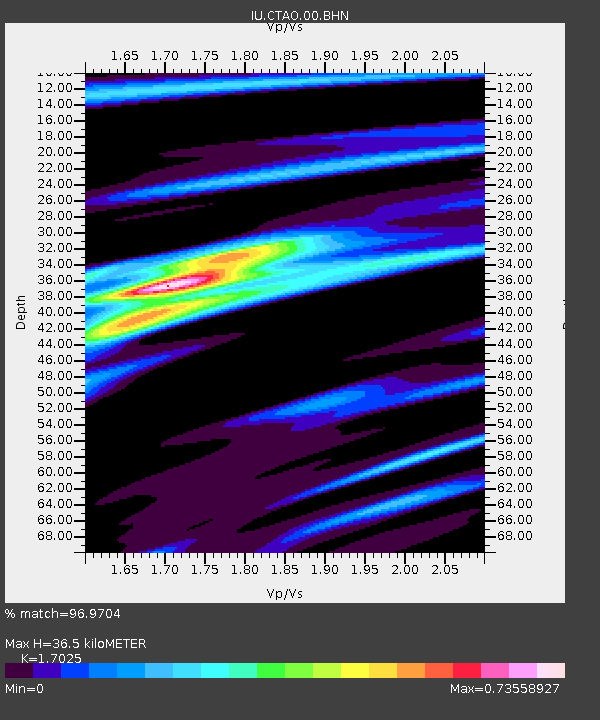
| Estimated Moho Depth: |
36.5 km |
| Estimated Crust Vp/Vs: |
1.70 |
| Assumed Crust Vp: |
6.522 km/s |
| Estimated Crust Vs: |
3.831 km/s |
| Estimated Crust Poisson's Ratio: |
0.24 |
|
| Radial Match: |
96.9704 % |
| Radial Bump: |
261 |
| Transverse Match: |
84.86838 % |
| Transverse Bump: |
400 |
| SOD ConfigId: |
2459 |
| Insert Time: |
2010-03-03 14:13:25.061 +0000 |
| GWidth: |
2.5 |
| Max Bumps: |
400 |
| Tol: |
0.001 |
|

Signal To Noise
| Channel | StoN | STA | LTA |
| IU:CTAO:00:BHN:20041008T14:43:18.361007Z | 3.9250836 | 4.3024158E-7 | 1.0961336E-7 |
| IU:CTAO:00:BHE:20041008T14:43:18.361007Z | 2.8879325 | 4.3510795E-7 | 1.5066416E-7 |
| IU:CTAO:00:BHZ:20041008T14:43:18.361007Z | 3.915991 | 1.030239E-6 | 2.6308513E-7 |
| Arrivals |
| Ps | 4.2 SECOND |
| PpPs | 14 SECOND |
| PsPs/PpSs | 18 SECOND |


