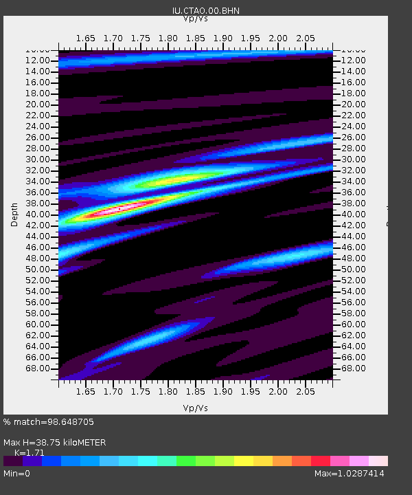
CTAO Charters Towers, Australia - Earthquake Result Viewer

Earthquake location: Near S. Coast Of Honshu, Japan
Earthquake latitude/longitude: 33.2/137.1
Earthquake time(UTC): 2004/09/05 (249) 14:57:18 GMT
Earthquake Depth: 10 km
Earthquake Magnitude: 6.2 MB, 7.1 MS, 7.4 MW, 7.4 MW
Earthquake Catalog/Contributor: WHDF/NEIC
Network: IU Global Seismograph Network (GSN - IRIS/USGS)
Station: CTAO Charters Towers, Australia
Lat/Lon: 20.09 S/146.25 E
Elevation: 357 m
Distance: 53.7 deg
Az: 169.272 deg
Baz: 350.44 deg
Ray Param: 0.06592836
Estimated Moho Depth: 38.75 km
Estimated Crust Vp/Vs: 1.71
Assumed Crust Vp: 6.522 km/s
Estimated Crust Vs: 3.814 km/s
Estimated Crust Poisson's Ratio: 0.24
Radial Match: 98.648705 %
Radial Bump: 231
Transverse Match: 88.57266 %
Transverse Bump: 400
SOD ConfigId: 2459
Insert Time: 2010-03-03 14:13:29.089 +0000
GWidth: 2.5
Max Bumps: 400
Tol: 0.001

Signal To Noise

ChannelStoNSTALTA
IU:CTAO:00:BHN:20040905T15:06:09.511001Z4.14951133.8919518E-79.379302E-8
IU:CTAO:00:BHE:20040905T15:06:09.511001Z1.47894931.7933772E-71.2126023E-7
IU:CTAO:00:BHZ:20040905T15:06:09.511001Z5.85737478.6264214E-71.4727455E-7
Arrivals
Ps4.5 SECOND
PpPs15 SECOND
PsPs/PpSs20 SECOND