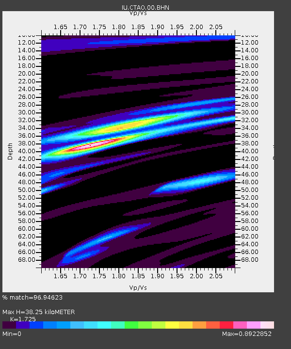
CTAO Charters Towers, Australia - Earthquake Result Viewer

Earthquake location: Near S. Coast Of Western Honshu
Earthquake latitude/longitude: 33.1/136.6
Earthquake time(UTC): 2004/09/05 (249) 10:07:07 GMT
Earthquake Depth: 14 km
Earthquake Magnitude: 6.7 MB, 7.0 MS, 7.2 MW, 7.0 MW
Earthquake Catalog/Contributor: WHDF/NEIC
Network: IU Global Seismograph Network (GSN - IRIS/USGS)
Station: CTAO Charters Towers, Australia
Lat/Lon: 20.09 S/146.25 E
Elevation: 357 m
Distance: 53.7 deg
Az: 168.736 deg
Baz: 349.95 deg
Ray Param: 0.06594455
Estimated Moho Depth: 38.25 km
Estimated Crust Vp/Vs: 1.73
Assumed Crust Vp: 6.522 km/s
Estimated Crust Vs: 3.781 km/s
Estimated Crust Poisson's Ratio: 0.25
Radial Match: 96.94623 %
Radial Bump: 215
Transverse Match: 81.61981 %
Transverse Bump: 400
SOD ConfigId: 2459
Insert Time: 2010-03-03 14:13:30.261 +0000
GWidth: 2.5
Max Bumps: 400
Tol: 0.001

Signal To Noise

ChannelStoNSTALTA
IU:CTAO:00:BHN:20040905T10:15:57.811028Z30.3743724.407762E-61.451145E-7
IU:CTAO:00:BHE:20040905T10:15:57.811028Z3.04907136.31014E-72.0695285E-7
IU:CTAO:00:BHZ:20040905T10:15:57.811028Z31.1955348.7833705E-62.8155858E-7
Arrivals
Ps4.5 SECOND
PpPs15 SECOND
PsPs/PpSs20 SECOND