You are here: Home > Network List > AK - Alaska Regional Network Stations List
> Station CCB Clear Creek Butte > Earthquake Result Viewer
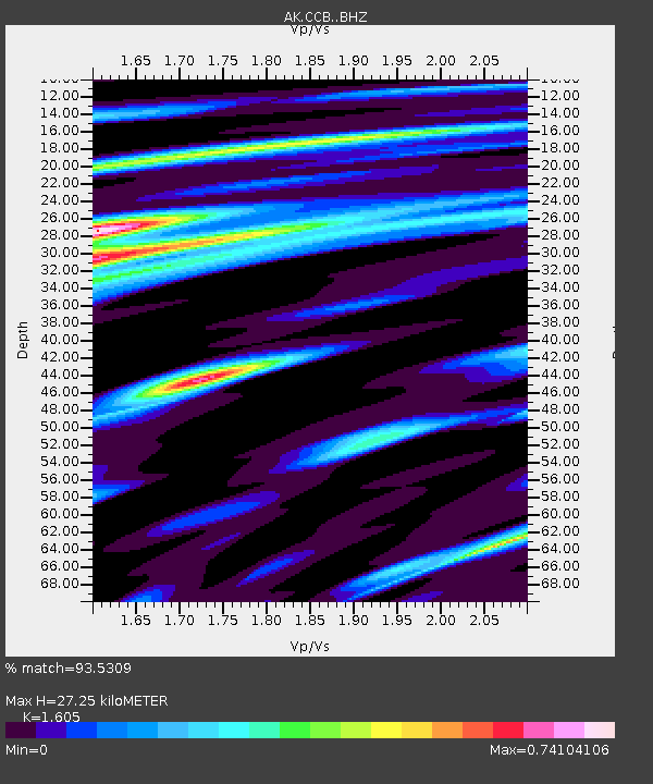
CCB Clear Creek Butte - Earthquake Result Viewer
| Earthquake location: |
Hokkaido, Japan Region |
| Earthquake latitude/longitude: |
41.5/142.0 |
| Earthquake time(UTC): |
2015/06/08 (159) 06:01:08 GMT |
| Earthquake Depth: |
44 km |
| Earthquake Magnitude: |
6.2 MO |
| Earthquake Catalog/Contributor: |
NEIC PDE/NEIC ALERT |
|
| Network: |
AK Alaska Regional Network |
| Station: |
CCB Clear Creek Butte |
| Lat/Lon: |
64.65 N/147.80 W |
| Elevation: |
248 m |
|
| Distance: |
45.2 deg |
| Az: |
34.83 deg |
| Baz: |
274.42 deg |
| Ray Param: |
0.071326345 |
| Estimated Moho Depth: |
27.25 km |
| Estimated Crust Vp/Vs: |
1.61 |
| Assumed Crust Vp: |
6.566 km/s |
| Estimated Crust Vs: |
4.091 km/s |
| Estimated Crust Poisson's Ratio: |
0.18 |
|
| Radial Match: |
93.5309 % |
| Radial Bump: |
310 |
| Transverse Match: |
80.6417 % |
| Transverse Bump: |
400 |
| SOD ConfigId: |
7422571 |
| Insert Time: |
2019-04-19 05:47:20.002 +0000 |
| GWidth: |
2.5 |
| Max Bumps: |
400 |
| Tol: |
0.001 |
|

Signal To Noise
| Channel | StoN | STA | LTA |
| AK:CCB: :BHZ:20150608T06:08:50.14801Z | 7.7459393 | 3.6379444E-7 | 4.6965827E-8 |
| AK:CCB: :BHN:20150608T06:08:50.14801Z | 0.74299437 | 3.772558E-8 | 5.0775057E-8 |
| AK:CCB: :BHE:20150608T06:08:50.14801Z | 4.135621 | 1.6483457E-7 | 3.9857273E-8 |
| Arrivals |
| Ps | 2.7 SECOND |
| PpPs | 10 SECOND |
| PsPs/PpSs | 13 SECOND |


