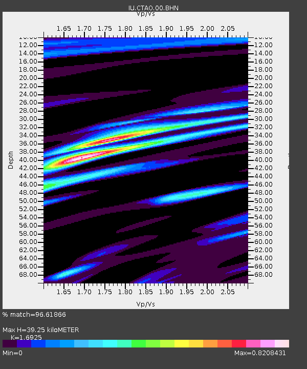
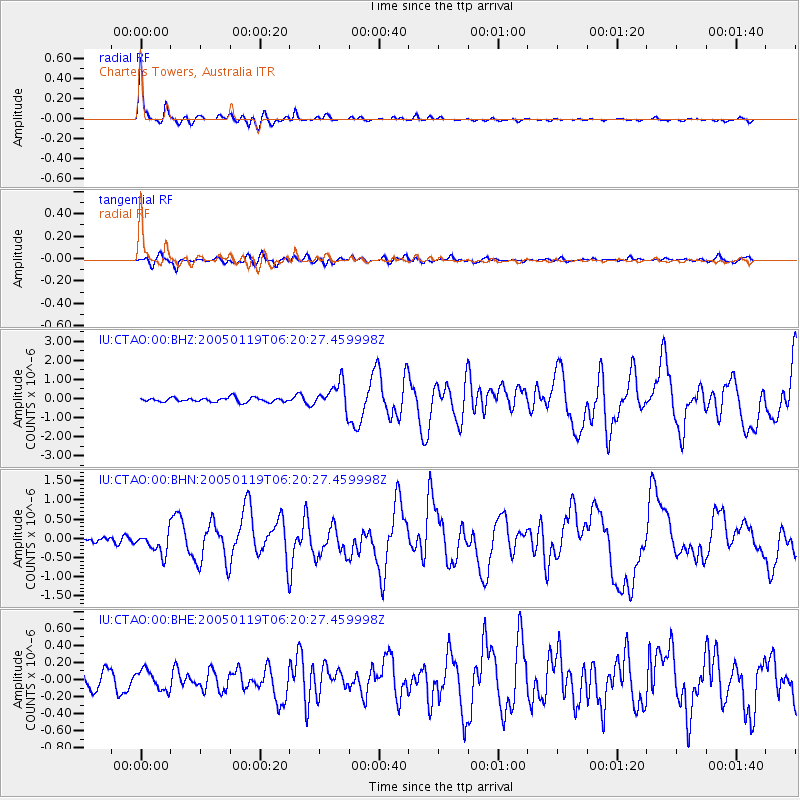
CTAO Charters Towers, Australia - Earthquake Result Viewer

Earthquake location: Off East Coast Of Honshu, Japan
Earthquake latitude/longitude: 34.1/141.5
Earthquake time(UTC): 2005/01/19 (019) 06:11:36 GMT
Earthquake Depth: 28 km
Earthquake Magnitude: 5.8 MB, 6.4 MS, 6.5 MW, 6.4 MW
Earthquake Catalog/Contributor: WHDF/NEIC
Network: IU Global Seismograph Network (GSN - IRIS/USGS)
Station: CTAO Charters Towers, Australia
Lat/Lon: 20.09 S/146.25 E
Elevation: 357 m
Distance: 54.0 deg
Az: 174.466 deg
Baz: 355.114 deg
Ray Param: 0.06565171
Estimated Moho Depth: 39.25 km
Estimated Crust Vp/Vs: 1.69
Assumed Crust Vp: 6.522 km/s
Estimated Crust Vs: 3.853 km/s
Estimated Crust Poisson's Ratio: 0.23
Radial Match: 96.61866 %
Radial Bump: 292
Transverse Match: 70.482635 %
Transverse Bump: 400
SOD ConfigId: 5233
Insert Time: 2010-03-03 14:14:22.917 +0000
GWidth: 2.5
Max Bumps: 400
Tol: 0.001

Signal To Noise

ChannelStoNSTALTA
IU:CTAO:00:BHN:20050119T06:20:27.459998Z4.5664452.8457657E-76.231907E-8
IU:CTAO:00:BHE:20050119T06:20:27.459998Z1.12300311.1521003E-71.0259101E-7
IU:CTAO:00:BHZ:20050119T06:20:27.459998Z6.11350876.9188155E-71.1317258E-7
Arrivals
Ps4.4 SECOND
PpPs15 SECOND
PsPs/PpSs20 SECOND