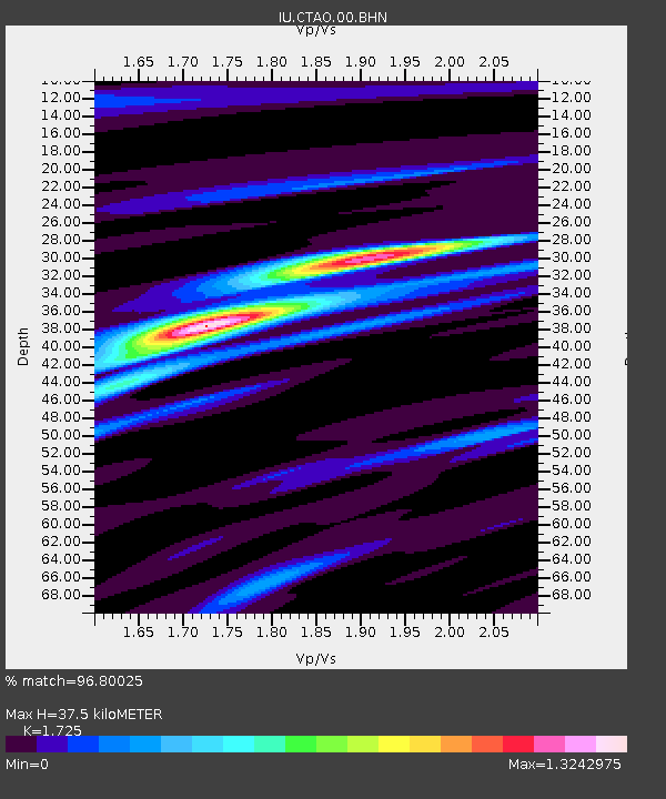
CTAO Charters Towers, Australia - Earthquake Result Viewer
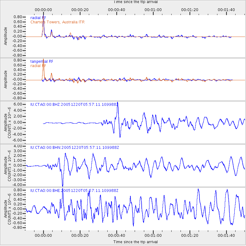
Earthquake location: W. Caroline Islands, Micronesia
Earthquake latitude/longitude: 12.2/141.0
Earthquake time(UTC): 2005/12/20 (354) 05:51:12 GMT
Earthquake Depth: 23 km
Earthquake Magnitude: 5.8 MB, 5.7 MS, 6.1 MW, 6.1 MW
Earthquake Catalog/Contributor: WHDF/NEIC
Network: IU Global Seismograph Network (GSN - IRIS/USGS)
Station: CTAO Charters Towers, Australia
Lat/Lon: 20.09 S/146.25 E
Elevation: 357 m
Distance: 32.5 deg
Az: 170.781 deg
Baz: 350.407 deg
Ray Param: 0.078585885
Estimated Moho Depth: 37.5 km
Estimated Crust Vp/Vs: 1.73
Assumed Crust Vp: 6.522 km/s
Estimated Crust Vs: 3.781 km/s
Estimated Crust Poisson's Ratio: 0.25
Radial Match: 96.80025 %
Radial Bump: 246
Transverse Match: 74.21645 %
Transverse Bump: 400
SOD ConfigId: 2422
Insert Time: 2010-03-03 14:14:24.325 +0000
GWidth: 2.5
Max Bumps: 400
Tol: 0.001

Signal To Noise

ChannelStoNSTALTA
IU:CTAO:00:BHN:20051220T05:57:11.109988Z4.7331912.6135544E-75.52176E-8
IU:CTAO:00:BHE:20051220T05:57:11.109988Z1.47060421.1467433E-77.79777E-8
IU:CTAO:00:BHZ:20051220T05:57:11.109988Z3.56264954.1692334E-71.170262E-7
Arrivals
Ps4.5 SECOND
PpPs14 SECOND
PsPs/PpSs19 SECOND