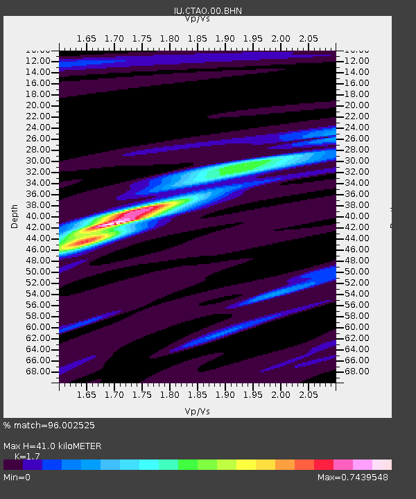
CTAO Charters Towers, Australia - Earthquake Result Viewer
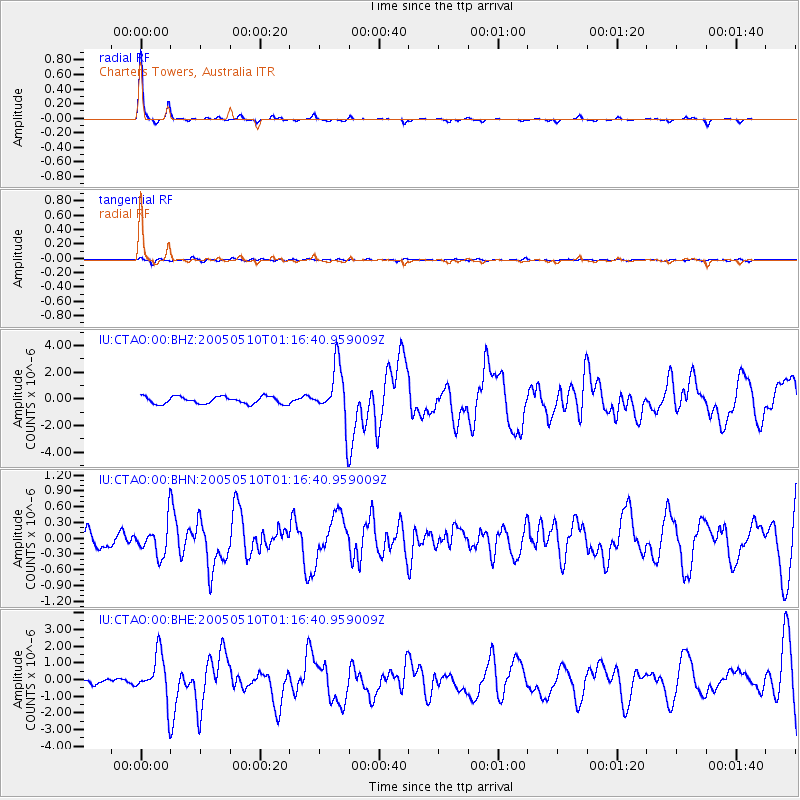
Earthquake location: Southwest Of Sumatra, Indonesia
Earthquake latitude/longitude: -6.2/103.1
Earthquake time(UTC): 2005/05/10 (130) 01:09:05 GMT
Earthquake Depth: 17 km
Earthquake Magnitude: 5.9 MB, 6.4 MS, 6.2 MW, 6.2 MW
Earthquake Catalog/Contributor: WHDF/NEIC
Network: IU Global Seismograph Network (GSN - IRIS/USGS)
Station: CTAO Charters Towers, Australia
Lat/Lon: 20.09 S/146.25 E
Elevation: 357 m
Distance: 44.0 deg
Az: 112.458 deg
Baz: 282.169 deg
Ray Param: 0.072145894
Estimated Moho Depth: 41.0 km
Estimated Crust Vp/Vs: 1.70
Assumed Crust Vp: 6.522 km/s
Estimated Crust Vs: 3.836 km/s
Estimated Crust Poisson's Ratio: 0.24
Radial Match: 96.002525 %
Radial Bump: 145
Transverse Match: 65.044205 %
Transverse Bump: 400
SOD ConfigId: 2455
Insert Time: 2010-03-03 14:15:19.683 +0000
GWidth: 2.5
Max Bumps: 400
Tol: 0.001

Signal To Noise

ChannelStoNSTALTA
IU:CTAO:00:BHN:20050510T01:16:40.959009Z2.01095873.1960857E-71.5893343E-7
IU:CTAO:00:BHE:20050510T01:16:40.959009Z14.09542751.4071563E-69.98307E-8
IU:CTAO:00:BHZ:20050510T01:16:40.959009Z7.83756162.1106341E-62.692973E-7
Arrivals
Ps4.7 SECOND
PpPs16 SECOND
PsPs/PpSs21 SECOND