You are here: Home > Network List > RV - Regional Alberta Seismic Observatory for Earthquake Studies Network Stations List
> Station ATHA Athabasca, AB > Earthquake Result Viewer
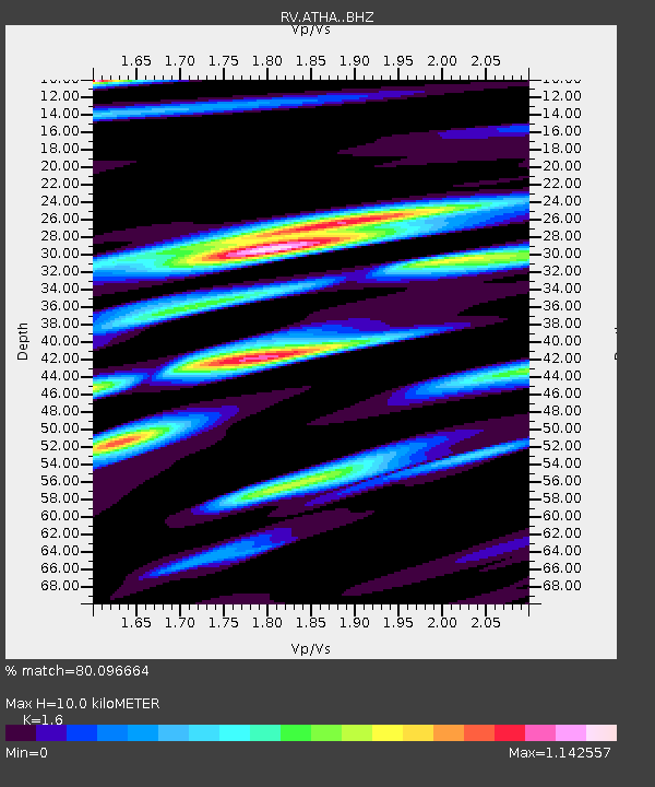
ATHA Athabasca, AB - Earthquake Result Viewer
| Earthquake location: |
Hokkaido, Japan Region |
| Earthquake latitude/longitude: |
41.5/142.0 |
| Earthquake time(UTC): |
2015/06/08 (159) 06:01:08 GMT |
| Earthquake Depth: |
44 km |
| Earthquake Magnitude: |
6.2 MO |
| Earthquake Catalog/Contributor: |
NEIC PDE/NEIC ALERT |
|
| Network: |
RV Regional Alberta Seismic Observatory for Earthquake Studies Network |
| Station: |
ATHA Athabasca, AB |
| Lat/Lon: |
54.71 N/113.31 W |
| Elevation: |
569 m |
|
| Distance: |
64.8 deg |
| Az: |
38.343 deg |
| Baz: |
306.526 deg |
| Ray Param: |
0.058624227 |
| Estimated Moho Depth: |
10.0 km |
| Estimated Crust Vp/Vs: |
1.60 |
| Assumed Crust Vp: |
6.444 km/s |
| Estimated Crust Vs: |
4.027 km/s |
| Estimated Crust Poisson's Ratio: |
0.18 |
|
| Radial Match: |
80.096664 % |
| Radial Bump: |
332 |
| Transverse Match: |
58.898823 % |
| Transverse Bump: |
400 |
| SOD ConfigId: |
7422571 |
| Insert Time: |
2019-04-19 05:53:25.188 +0000 |
| GWidth: |
2.5 |
| Max Bumps: |
400 |
| Tol: |
0.001 |
|

Signal To Noise
| Channel | StoN | STA | LTA |
| RV:ATHA: :BHZ:20150608T06:11:11.174988Z | 2.0083878 | 2.6145963E-7 | 1.3018384E-7 |
| RV:ATHA: :BHN:20150608T06:11:11.174988Z | 0.5673356 | 1.2196625E-7 | 2.1498077E-7 |
| RV:ATHA: :BHE:20150608T06:11:11.174988Z | 1.081659 | 1.5094359E-7 | 1.3954822E-7 |
| Arrivals |
| Ps | 1.0 SECOND |
| PpPs | 3.8 SECOND |
| PsPs/PpSs | 4.8 SECOND |


