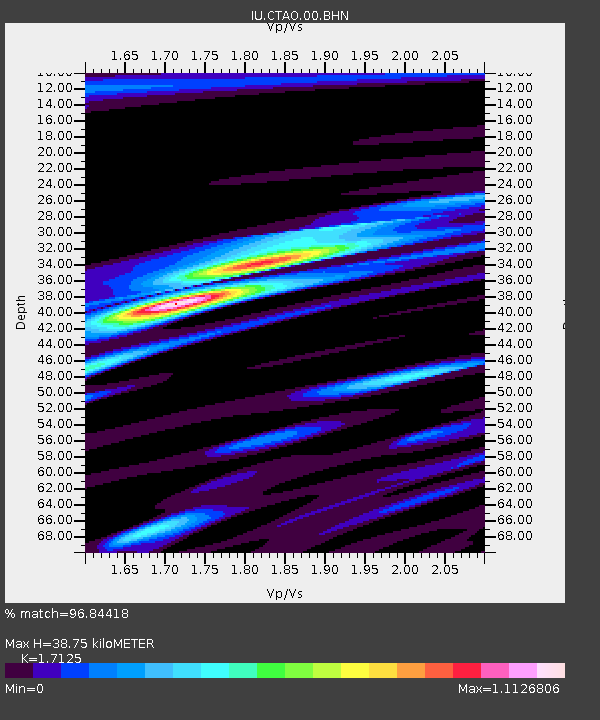
CTAO Charters Towers, Australia - Earthquake Result Viewer

Earthquake location: Near East Coast Of Honshu, Japan
Earthquake latitude/longitude: 38.3/142.0
Earthquake time(UTC): 2005/08/16 (228) 02:46:28 GMT
Earthquake Depth: 36 km
Earthquake Magnitude: 6.5 MB, 6.8 MS, 7.2 MW, 7.1 MW
Earthquake Catalog/Contributor: WHDF/NEIC
Network: IU Global Seismograph Network (GSN - IRIS/USGS)
Station: CTAO Charters Towers, Australia
Lat/Lon: 20.09 S/146.25 E
Elevation: 357 m
Distance: 58.2 deg
Az: 175.337 deg
Baz: 356.096 deg
Ray Param: 0.062940754
Estimated Moho Depth: 38.75 km
Estimated Crust Vp/Vs: 1.71
Assumed Crust Vp: 6.522 km/s
Estimated Crust Vs: 3.808 km/s
Estimated Crust Poisson's Ratio: 0.24
Radial Match: 96.84418 %
Radial Bump: 334
Transverse Match: 89.8086 %
Transverse Bump: 400
SOD ConfigId: 2475
Insert Time: 2010-03-03 14:15:29.288 +0000
GWidth: 2.5
Max Bumps: 400
Tol: 0.001

Signal To Noise

ChannelStoNSTALTA
IU:CTAO:00:BHN:20050816T02:55:48.16001Z1.97905112.8011186E-71.4153846E-7
IU:CTAO:00:BHE:20050816T02:55:48.16001Z1.2113361.8939099E-71.5634883E-7
IU:CTAO:00:BHZ:20050816T02:55:48.16001Z5.34083758.4406895E-71.5804056E-7
Arrivals
Ps4.5 SECOND
PpPs15 SECOND
PsPs/PpSs20 SECOND