You are here: Home > Network List > TA - USArray Transportable Network (new EarthScope stations) Stations List
> Station MSTX Muleshoe, TX, USA > Earthquake Result Viewer
MSTX Muleshoe, TX, USA - Earthquake Result Viewer
*The percent match for this event was below the threshold and hence no stack was calculated.
| Earthquake location: |
Hokkaido, Japan Region |
| Earthquake latitude/longitude: |
41.5/142.0 |
| Earthquake time(UTC): |
2015/06/08 (159) 06:01:08 GMT |
| Earthquake Depth: |
44 km |
| Earthquake Magnitude: |
6.2 MO |
| Earthquake Catalog/Contributor: |
NEIC PDE/NEIC ALERT |
|
| Network: |
TA USArray Transportable Network (new EarthScope stations) |
| Station: |
MSTX Muleshoe, TX, USA |
| Lat/Lon: |
33.97 N/102.77 W |
| Elevation: |
1167 m |
|
| Distance: |
84.3 deg |
| Az: |
49.053 deg |
| Baz: |
316.912 deg |
| Ray Param: |
$rayparam |
*The percent match for this event was below the threshold and hence was not used in the summary stack. |
|
| Radial Match: |
50.51354 % |
| Radial Bump: |
400 |
| Transverse Match: |
56.695663 % |
| Transverse Bump: |
400 |
| SOD ConfigId: |
7422571 |
| Insert Time: |
2019-04-19 05:54:25.573 +0000 |
| GWidth: |
2.5 |
| Max Bumps: |
400 |
| Tol: |
0.001 |
|
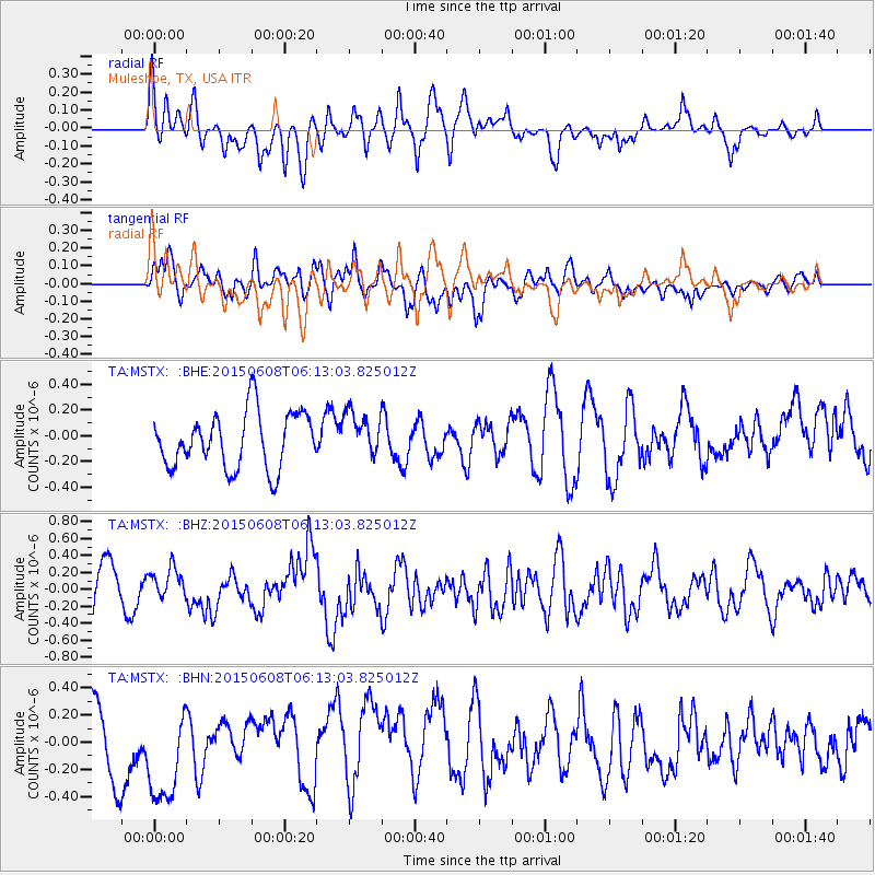
Signal To Noise
| Channel | StoN | STA | LTA |
| TA:MSTX: :BHZ:20150608T06:13:03.825012Z | 0.7926725 | 1.8403937E-7 | 2.3217578E-7 |
| TA:MSTX: :BHN:20150608T06:13:03.825012Z | 2.062658 | 3.9011167E-7 | 1.8913056E-7 |
| TA:MSTX: :BHE:20150608T06:13:03.825012Z | 0.85583234 | 1.8276914E-7 | 2.1355719E-7 |
| Arrivals |
| Ps | |
| PpPs | |
| PsPs/PpSs | |


