You are here: Home > Network List > IU - Global Seismograph Network (GSN - IRIS/USGS) Stations List
> Station CTAO Charters Towers, Australia > Earthquake Result Viewer
CTAO Charters Towers, Australia - Earthquake Result Viewer
| Earthquake location: |
Macquarie Island Region |
| Earthquake latitude/longitude: |
-55.7/158.5 |
| Earthquake time(UTC): |
2008/04/12 (103) 00:30:12 GMT |
| Earthquake Depth: |
16 km |
| Earthquake Magnitude: |
6.8 MB, 7.1 MS, 7.1 MW, 7.1 MW |
| Earthquake Catalog/Contributor: |
WHDF/NEIC |
|
| Network: |
IU Global Seismograph Network (GSN - IRIS/USGS) |
| Station: |
CTAO Charters Towers, Australia |
| Lat/Lon: |
20.09 S/146.25 E |
| Elevation: |
357 m |
|
| Distance: |
36.7 deg |
| Az: |
340.585 deg |
| Baz: |
168.44 deg |
| Ray Param: |
0.07652906 |
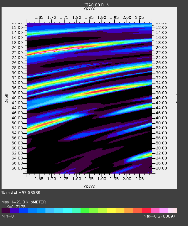
| Estimated Moho Depth: |
21.0 km |
| Estimated Crust Vp/Vs: |
1.72 |
| Assumed Crust Vp: |
6.522 km/s |
| Estimated Crust Vs: |
3.797 km/s |
| Estimated Crust Poisson's Ratio: |
0.24 |
|
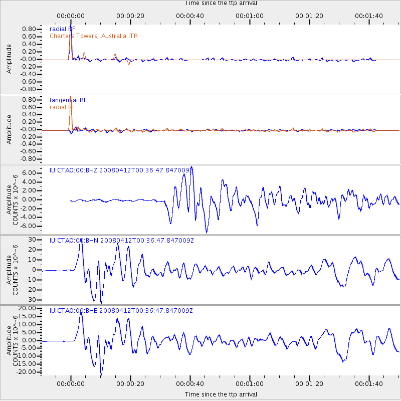
| Radial Match: |
97.53589 % |
| Radial Bump: |
206 |
| Transverse Match: |
85.944275 % |
| Transverse Bump: |
400 |
| SOD ConfigId: |
2504 |
| Insert Time: |
2010-03-03 14:15:39.947 +0000 |
| GWidth: |
2.5 |
| Max Bumps: |
400 |
| Tol: |
0.001 |
|
Signal To Noise
| Channel | StoN | STA | LTA |
| IU:CTAO:00:BHN:20080412T00:36:47.847009Z | 41.58824 | 1.3860584E-5 | 3.332813E-7 |
| IU:CTAO:00:BHE:20080412T00:36:47.847009Z | 65.07876 | 8.223151E-6 | 1.2635692E-7 |
| IU:CTAO:00:BHZ:20080412T00:36:47.847009Z | 14.456443 | 2.2547902E-6 | 1.5597129E-7 |
| Arrivals |
| Ps | 2.5 SECOND |
| PpPs | 8.1 SECOND |
| PsPs/PpSs | 11 SECOND |


