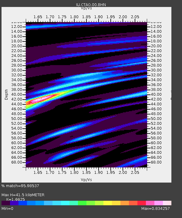
CTAO Charters Towers, Australia - Earthquake Result Viewer

Earthquake location: Southern Sumatra, Indonesia
Earthquake latitude/longitude: -2.2/99.8
Earthquake time(UTC): 2008/02/25 (056) 21:02:18 GMT
Earthquake Depth: 25 km
Earthquake Magnitude: 6.2 MB, 6.6 MS, 6.6 MW, 6.5 MW
Earthquake Catalog/Contributor: WHDF/NEIC
Network: IU Global Seismograph Network (GSN - IRIS/USGS)
Station: CTAO Charters Towers, Australia
Lat/Lon: 20.09 S/146.25 E
Elevation: 357 m
Distance: 48.7 deg
Az: 114.885 deg
Baz: 285.329 deg
Ray Param: 0.069166616
Estimated Moho Depth: 41.5 km
Estimated Crust Vp/Vs: 1.66
Assumed Crust Vp: 6.522 km/s
Estimated Crust Vs: 3.923 km/s
Estimated Crust Poisson's Ratio: 0.22
Radial Match: 95.98537 %
Radial Bump: 225
Transverse Match: 82.19139 %
Transverse Bump: 400
SOD ConfigId: 2564
Insert Time: 2010-03-03 14:16:53.217 +0000
GWidth: 2.5
Max Bumps: 400
Tol: 0.001

Signal To Noise

ChannelStoNSTALTA
IU:CTAO:00:BHN:20080225T21:10:29.598009Z4.24493747.7086605E-71.8159658E-7
IU:CTAO:00:BHE:20080225T21:10:29.598009Z14.1815362.2586064E-61.5926389E-7
IU:CTAO:00:BHZ:20080225T21:10:29.598009Z17.7496193.8304242E-62.1580318E-7
Arrivals
Ps4.5 SECOND
PpPs16 SECOND
PsPs/PpSs20 SECOND