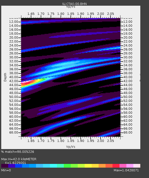
CTAO Charters Towers, Australia - Earthquake Result Viewer
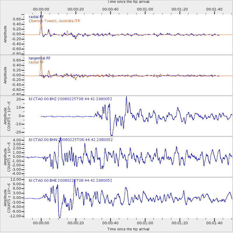
Earthquake location: Southern Sumatra, Indonesia
Earthquake latitude/longitude: -2.5/100.0
Earthquake time(UTC): 2008/02/25 (056) 08:36:33 GMT
Earthquake Depth: 25 km
Earthquake Magnitude: 6.4 MB, 7.3 MS, 7.0 MW, 6.9 MW
Earthquake Catalog/Contributor: WHDF/NEIC
Network: IU Global Seismograph Network (GSN - IRIS/USGS)
Station: CTAO Charters Towers, Australia
Lat/Lon: 20.09 S/146.25 E
Elevation: 357 m
Distance: 48.4 deg
Az: 114.747 deg
Baz: 285.131 deg
Ray Param: 0.06933321
Estimated Moho Depth: 42.0 km
Estimated Crust Vp/Vs: 1.62
Assumed Crust Vp: 6.522 km/s
Estimated Crust Vs: 4.019 km/s
Estimated Crust Poisson's Ratio: 0.19
Radial Match: 98.005226 %
Radial Bump: 293
Transverse Match: 91.04163 %
Transverse Bump: 400
SOD ConfigId: 2564
Insert Time: 2010-03-03 14:16:58.021 +0000
GWidth: 2.5
Max Bumps: 400
Tol: 0.001

Signal To Noise

ChannelStoNSTALTA
IU:CTAO:00:BHN:20080225T08:44:42.298005Z3.1435293.022831E-79.616043E-8
IU:CTAO:00:BHE:20080225T08:44:42.298005Z12.47209551.184365E-69.4961194E-8
IU:CTAO:00:BHZ:20080225T08:44:42.298005Z8.4811112.1549124E-62.5408377E-7
Arrivals
Ps4.3 SECOND
PpPs16 SECOND
PsPs/PpSs20 SECOND