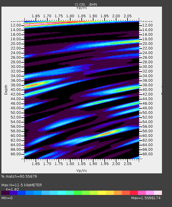
OSI Osito Audit - Earthquake Result Viewer
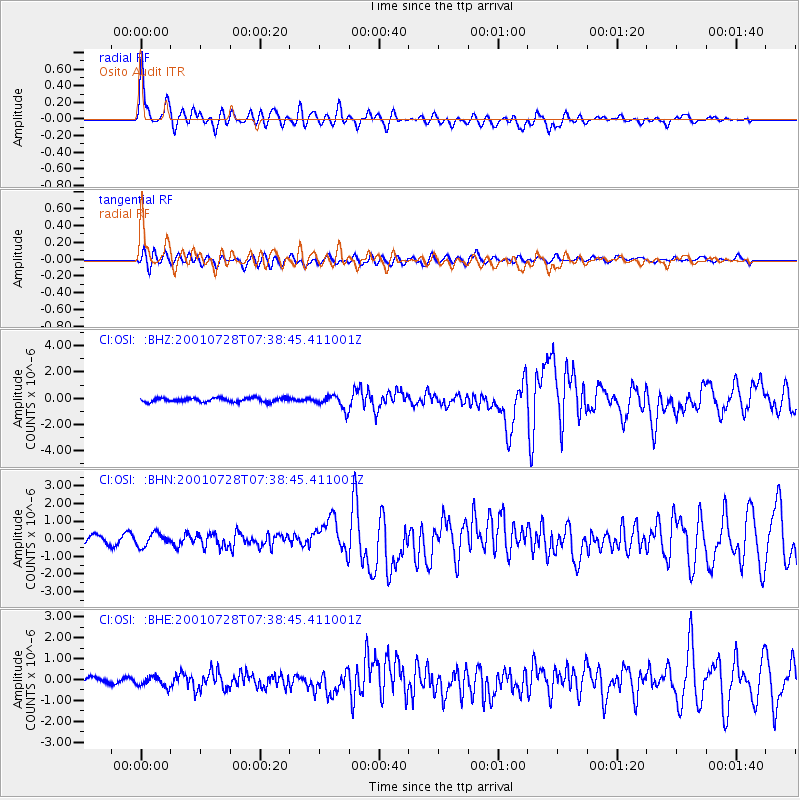
Earthquake location: Southern Alaska
Earthquake latitude/longitude: 59.0/-155.1
Earthquake time(UTC): 2001/07/28 (209) 07:32:43 GMT
Earthquake Depth: 131 km
Earthquake Magnitude: 5.7 MB, 5.7 MS, 6.6 MW, 6.2 ME
Earthquake Catalog/Contributor: WHDF/NEIC
Network: CI Caltech Regional Seismic Network
Station: OSI Osito Audit
Lat/Lon: 34.61 N/118.72 W
Elevation: 718 m
Distance: 34.2 deg
Az: 119.402 deg
Baz: 326.885 deg
Ray Param: 0.07744453
Estimated Moho Depth: 11.5 km
Estimated Crust Vp/Vs: 1.62
Assumed Crust Vp: 6.1 km/s
Estimated Crust Vs: 3.765 km/s
Estimated Crust Poisson's Ratio: 0.19
Radial Match: 90.55679 %
Radial Bump: 400
Transverse Match: 70.13795 %
Transverse Bump: 400
SOD ConfigId: 3753
Insert Time: 2010-02-25 21:30:26.101 +0000
GWidth: 2.5
Max Bumps: 400
Tol: 0.001

Signal To Noise

ChannelStoNSTALTA
CI:OSI: :BHN:20010728T07:38:45.411001Z2.2791933.7029105E-71.6246587E-7
CI:OSI: :BHE:20010728T07:38:45.411001Z0.99868372.4176492E-72.420836E-7
CI:OSI: :BHZ:20010728T07:38:45.411001Z3.3593565.1247775E-71.5255239E-7
Arrivals
Ps1.3 SECOND
PpPs4.6 SECOND
PsPs/PpSs5.8 SECOND