You are here: Home > Network List > TA - USArray Transportable Network (new EarthScope stations) Stations List
> Station X43A Marvell, AR, USA > Earthquake Result Viewer
X43A Marvell, AR, USA - Earthquake Result Viewer
| Earthquake location: |
Tonga Islands |
| Earthquake latitude/longitude: |
-15.2/-173.1 |
| Earthquake time(UTC): |
2015/06/08 (159) 15:01:03 GMT |
| Earthquake Depth: |
14 km |
| Earthquake Magnitude: |
5.5 MW |
| Earthquake Catalog/Contributor: |
ISC/ISC |
|
| Network: |
TA USArray Transportable Network (new EarthScope stations) |
| Station: |
X43A Marvell, AR, USA |
| Lat/Lon: |
34.52 N/90.88 W |
| Elevation: |
53 m |
|
| Distance: |
92.2 deg |
| Az: |
54.95 deg |
| Baz: |
253.192 deg |
| Ray Param: |
0.041492913 |
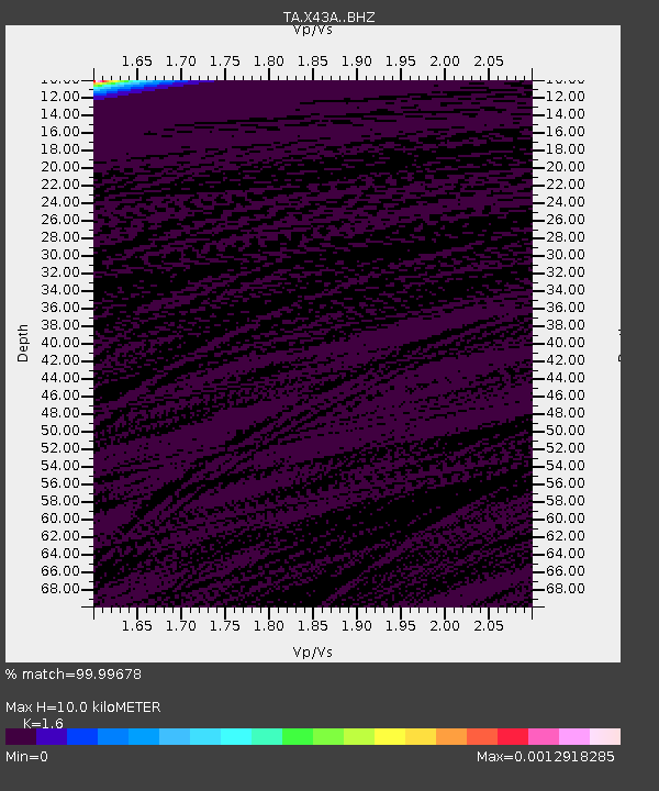
| Estimated Moho Depth: |
10.0 km |
| Estimated Crust Vp/Vs: |
1.60 |
| Assumed Crust Vp: |
6.273 km/s |
| Estimated Crust Vs: |
3.921 km/s |
| Estimated Crust Poisson's Ratio: |
0.18 |
|
| Radial Match: |
99.99678 % |
| Radial Bump: |
2 |
| Transverse Match: |
99.99853 % |
| Transverse Bump: |
2 |
| SOD ConfigId: |
7422571 |
| Insert Time: |
2019-04-19 06:06:31.015 +0000 |
| GWidth: |
2.5 |
| Max Bumps: |
400 |
| Tol: |
0.001 |
|

Signal To Noise
| Channel | StoN | STA | LTA |
| TA:X43A: :BHZ:20150608T15:13:41.499998Z | 2.4599063 | 7.347407E-5 | 2.9868645E-5 |
| TA:X43A: :BHN:20150608T15:13:41.499998Z | 2.4612527 | 9.3136325E-5 | 3.7841022E-5 |
| TA:X43A: :BHE:20150608T15:13:41.499998Z | 2.4270575 | 5.0462924E-5 | 2.0791813E-5 |
| Arrivals |
| Ps | 1.0 SECOND |
| PpPs | 4.1 SECOND |
| PsPs/PpSs | 5.0 SECOND |


