You are here: Home > Network List > IU - Global Seismograph Network (GSN - IRIS/USGS) Stations List
> Station CTAO Charters Towers, Australia > Earthquake Result Viewer
CTAO Charters Towers, Australia - Earthquake Result Viewer
| Earthquake location: |
Fiji Islands Region |
| Earthquake latitude/longitude: |
-21.0/-178.6 |
| Earthquake time(UTC): |
1991/09/30 (273) 00:21:47 GMT |
| Earthquake Depth: |
580 km |
| Earthquake Magnitude: |
6.0 MB, 6.5 UNKNOWN |
| Earthquake Catalog/Contributor: |
WHDF/NEIC |
|
| Network: |
IU Global Seismograph Network (GSN - IRIS/USGS) |
| Station: |
CTAO Charters Towers, Australia |
| Lat/Lon: |
20.09 S/146.25 E |
| Elevation: |
357 m |
|
| Distance: |
32.9 deg |
| Az: |
265.183 deg |
| Baz: |
97.782 deg |
| Ray Param: |
0.07566841 |
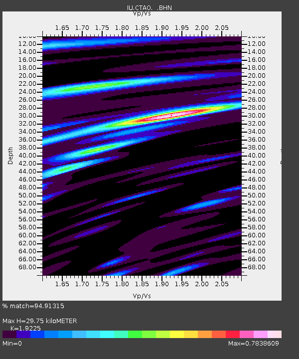
| Estimated Moho Depth: |
29.75 km |
| Estimated Crust Vp/Vs: |
1.92 |
| Assumed Crust Vp: |
6.522 km/s |
| Estimated Crust Vs: |
3.392 km/s |
| Estimated Crust Poisson's Ratio: |
0.31 |
|
| Radial Match: |
94.91315 % |
| Radial Bump: |
326 |
| Transverse Match: |
76.245865 % |
| Transverse Bump: |
400 |
| SOD ConfigId: |
16938 |
| Insert Time: |
2010-03-03 14:17:19.949 +0000 |
| GWidth: |
2.5 |
| Max Bumps: |
400 |
| Tol: |
0.001 |
|

Signal To Noise
| Channel | StoN | STA | LTA |
| IU:CTAO: :BHN:19910930T00:27:04.273987Z | 2.503202 | 5.236563E-7 | 2.0919461E-7 |
| IU:CTAO: :BHE:19910930T00:27:04.277008Z | 22.456942 | 7.964186E-6 | 3.5464248E-7 |
| IU:CTAO: :BHZ:19910930T00:27:04.273987Z | 91.464516 | 1.380975E-5 | 1.5098479E-7 |
| Arrivals |
| Ps | 4.5 SECOND |
| PpPs | 12 SECOND |
| PsPs/PpSs | 17 SECOND |


