You are here: Home > Network List > IU - Global Seismograph Network (GSN - IRIS/USGS) Stations List
> Station CTAO Charters Towers, Australia > Earthquake Result Viewer
CTAO Charters Towers, Australia - Earthquake Result Viewer

| Earthquake location: |
South Of Fiji Islands |
| Earthquake latitude/longitude: |
-26.3/178.6 |
| Earthquake time(UTC): |
1991/12/03 (337) 10:33:42 GMT |
| Earthquake Depth: |
581 km |
| Earthquake Magnitude: |
5.8 MB |
| Earthquake Catalog/Contributor: |
WHDF/NEIC |
|
| Network: |
IU Global Seismograph Network (GSN - IRIS/USGS) |
| Station: |
CTAO Charters Towers, Australia |
| Lat/Lon: |
20.09 S/146.25 E |
| Elevation: |
357 m |
|
| Distance: |
30.3 deg |
| Az: |
274.979 deg |
| Baz: |
107.947 deg |
| Ray Param: |
0.07698175 |
| Estimated Moho Depth: |
25.25 km |
| Estimated Crust Vp/Vs: |
2.09 |
| Assumed Crust Vp: |
6.522 km/s |
| Estimated Crust Vs: |
3.12 km/s |
| Estimated Crust Poisson's Ratio: |
0.35 |
|
| Radial Match: |
96.11639 % |
| Radial Bump: |
204 |
| Transverse Match: |
83.35559 % |
| Transverse Bump: |
400 |
| SOD ConfigId: |
17000 |
| Insert Time: |
2010-03-03 14:17:43.302 +0000 |
| GWidth: |
2.5 |
| Max Bumps: |
400 |
| Tol: |
0.001 |
|
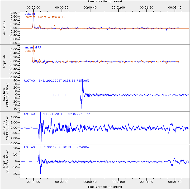
Signal To Noise
| Channel | StoN | STA | LTA |
| IU:CTAO: :BHN:19911203T10:38:36.725006Z | 27.05837 | 1.6550572E-6 | 6.116618E-8 |
| IU:CTAO: :BHE:19911203T10:38:36.725006Z | 78.4228 | 6.5485233E-6 | 8.3502805E-8 |
| IU:CTAO: :BHZ:19911203T10:38:36.725006Z | 116.40964 | 1.15281155E-5 | 9.903059E-8 |
| Arrivals |
| Ps | 4.5 SECOND |
| PpPs | 11 SECOND |
| PsPs/PpSs | 16 SECOND |


