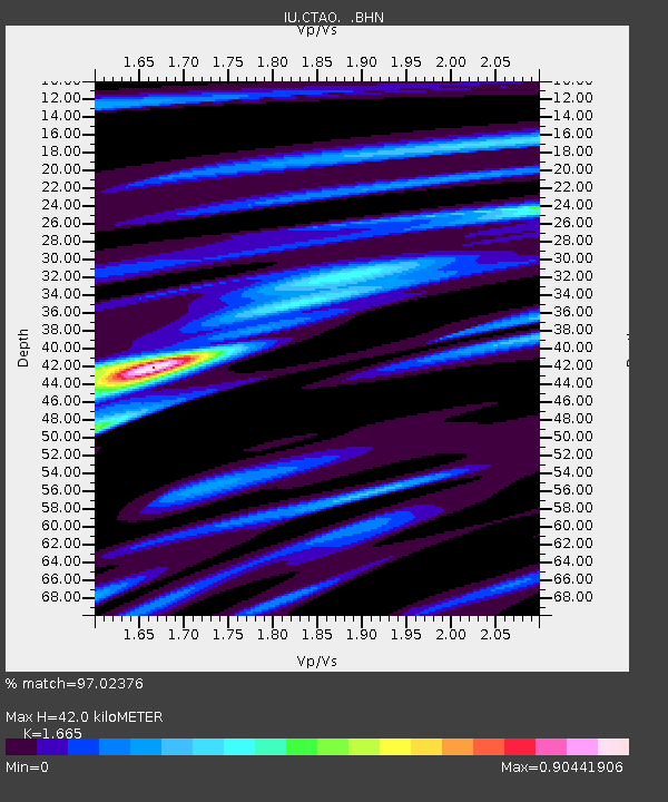
CTAO Charters Towers, Australia - Earthquake Result Viewer

Earthquake location: Southern Sumatra, Indonesia
Earthquake latitude/longitude: -5.8/103.2
Earthquake time(UTC): 1992/02/06 (037) 01:12:39 GMT
Earthquake Depth: 45 km
Earthquake Magnitude: 5.9 MB, 6.4 MS, 6.3 UNKNOWN
Earthquake Catalog/Contributor: WHDF/NEIC
Network: IU Global Seismograph Network (GSN - IRIS/USGS)
Station: CTAO Charters Towers, Australia
Lat/Lon: 20.09 S/146.25 E
Elevation: 357 m
Distance: 44.2 deg
Az: 112.894 deg
Baz: 282.778 deg
Ray Param: 0.07195227
Estimated Moho Depth: 42.0 km
Estimated Crust Vp/Vs: 1.66
Assumed Crust Vp: 6.522 km/s
Estimated Crust Vs: 3.917 km/s
Estimated Crust Poisson's Ratio: 0.22
Radial Match: 97.02376 %
Radial Bump: 221
Transverse Match: 89.30564 %
Transverse Bump: 400
SOD ConfigId: 16938
Insert Time: 2010-03-03 14:17:48.061 +0000
GWidth: 2.5
Max Bumps: 400
Tol: 0.001

Signal To Noise

ChannelStoNSTALTA
IU:CTAO: :BHN:19920206T01:20:13.477002Z1.8176291.2809038E-77.047113E-8
IU:CTAO: :BHE:19920206T01:20:13.477002Z7.0383155.482076E-77.788904E-8
IU:CTAO: :BHZ:19920206T01:20:13.477002Z11.4048311.1199967E-69.820371E-8
Arrivals
Ps4.6 SECOND
PpPs16 SECOND
PsPs/PpSs21 SECOND