You are here: Home > Network List > IU - Global Seismograph Network (GSN - IRIS/USGS) Stations List
> Station CTAO Charters Towers, Australia > Earthquake Result Viewer
CTAO Charters Towers, Australia - Earthquake Result Viewer
| Earthquake location: |
South Of Fiji Islands |
| Earthquake latitude/longitude: |
-22.3/-178.5 |
| Earthquake time(UTC): |
1992/07/11 (193) 10:44:20 GMT |
| Earthquake Depth: |
381 km |
| Earthquake Magnitude: |
6.2 MB |
| Earthquake Catalog/Contributor: |
WHDF/NEIC |
|
| Network: |
IU Global Seismograph Network (GSN - IRIS/USGS) |
| Station: |
CTAO Charters Towers, Australia |
| Lat/Lon: |
20.09 S/146.25 E |
| Elevation: |
357 m |
|
| Distance: |
32.9 deg |
| Az: |
267.17 deg |
| Baz: |
100.192 deg |
| Ray Param: |
0.07697333 |
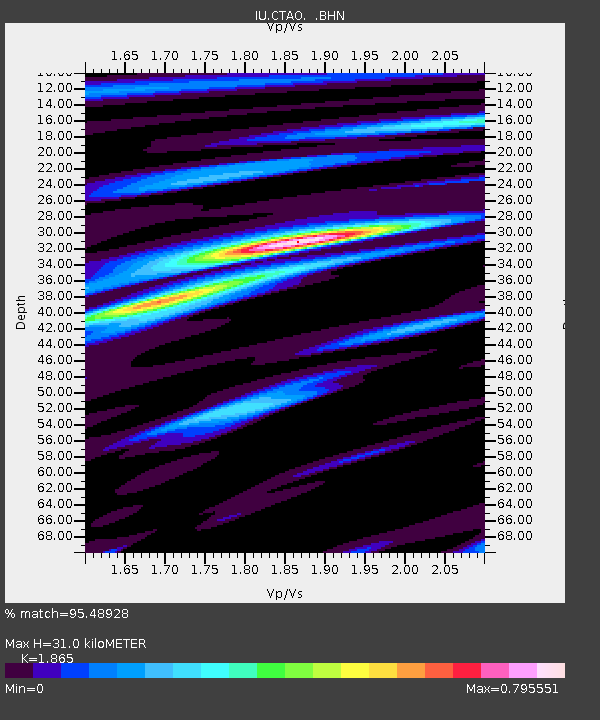
| Estimated Moho Depth: |
31.0 km |
| Estimated Crust Vp/Vs: |
1.87 |
| Assumed Crust Vp: |
6.522 km/s |
| Estimated Crust Vs: |
3.497 km/s |
| Estimated Crust Poisson's Ratio: |
0.30 |
|
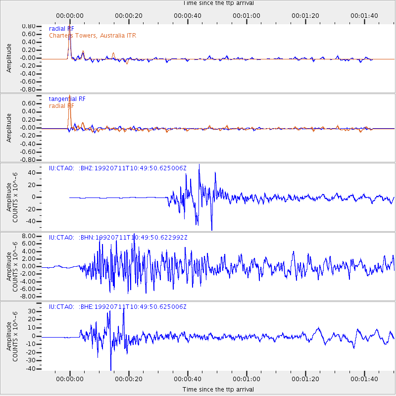
| Radial Match: |
95.48928 % |
| Radial Bump: |
254 |
| Transverse Match: |
87.7502 % |
| Transverse Bump: |
400 |
| SOD ConfigId: |
16938 |
| Insert Time: |
2010-03-03 14:17:59.820 +0000 |
| GWidth: |
2.5 |
| Max Bumps: |
400 |
| Tol: |
0.001 |
|
Signal To Noise
| Channel | StoN | STA | LTA |
| IU:CTAO: :BHN:19920711T10:49:50.622992Z | 1.704292 | 3.1752776E-7 | 1.8631064E-7 |
| IU:CTAO: :BHE:19920711T10:49:50.625006Z | 15.144483 | 2.4367541E-6 | 1.6090044E-7 |
| IU:CTAO: :BHZ:19920711T10:49:50.625006Z | 11.428189 | 4.106692E-6 | 3.5934755E-7 |
| Arrivals |
| Ps | 4.4 SECOND |
| PpPs | 13 SECOND |
| PsPs/PpSs | 17 SECOND |


