You are here: Home > Network List > IU - Global Seismograph Network (GSN - IRIS/USGS) Stations List
> Station CTAO Charters Towers, Australia > Earthquake Result Viewer
CTAO Charters Towers, Australia - Earthquake Result Viewer
| Earthquake location: |
Kyrgyzstan |
| Earthquake latitude/longitude: |
42.1/73.6 |
| Earthquake time(UTC): |
1992/08/19 (232) 02:04:36 GMT |
| Earthquake Depth: |
22 km |
| Earthquake Magnitude: |
6.8 MB, 7.4 MS |
| Earthquake Catalog/Contributor: |
WHDF/NEIC |
|
| Network: |
IU Global Seismograph Network (GSN - IRIS/USGS) |
| Station: |
CTAO Charters Towers, Australia |
| Lat/Lon: |
20.09 S/146.25 E |
| Elevation: |
357 m |
|
| Distance: |
91.1 deg |
| Az: |
116.163 deg |
| Baz: |
314.696 deg |
| Ray Param: |
0.041621376 |
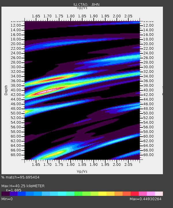
| Estimated Moho Depth: |
40.25 km |
| Estimated Crust Vp/Vs: |
1.70 |
| Assumed Crust Vp: |
6.522 km/s |
| Estimated Crust Vs: |
3.848 km/s |
| Estimated Crust Poisson's Ratio: |
0.23 |
|
| Radial Match: |
95.695404 % |
| Radial Bump: |
339 |
| Transverse Match: |
78.26132 % |
| Transverse Bump: |
400 |
| SOD ConfigId: |
16938 |
| Insert Time: |
2010-03-03 14:18:06.890 +0000 |
| GWidth: |
2.5 |
| Max Bumps: |
400 |
| Tol: |
0.001 |
|
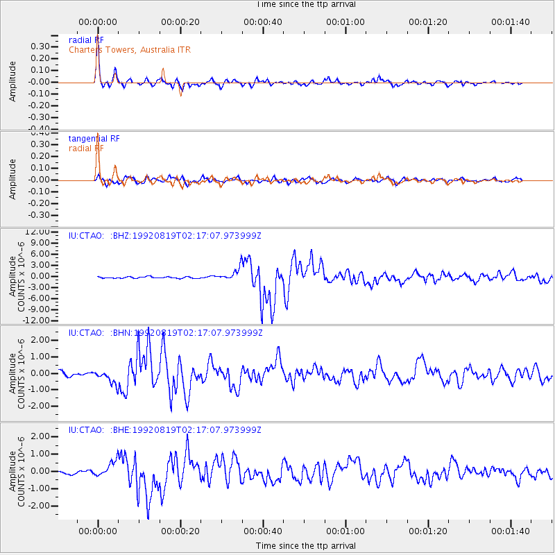
Signal To Noise
| Channel | StoN | STA | LTA |
| IU:CTAO: :BHN:19920819T02:17:07.973999Z | 2.4502509 | 4.1564186E-7 | 1.6963237E-7 |
| IU:CTAO: :BHE:19920819T02:17:07.973999Z | 4.350793 | 4.5931804E-7 | 1.0557111E-7 |
| IU:CTAO: :BHZ:19920819T02:17:07.973999Z | 8.82169 | 1.7802596E-6 | 2.0180484E-7 |
| Arrivals |
| Ps | 4.4 SECOND |
| PpPs | 16 SECOND |
| PsPs/PpSs | 21 SECOND |


