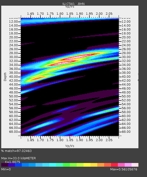
CTAO Charters Towers, Australia - Earthquake Result Viewer

Earthquake location: Near East Coast Of Kamchatka
Earthquake latitude/longitude: 51.9/158.7
Earthquake time(UTC): 1993/11/13 (317) 01:18:04 GMT
Earthquake Depth: 34 km
Earthquake Magnitude: 6.5 MB, 7.1 MS, 6.9 UNKNOWN
Earthquake Catalog/Contributor: WHDF/NEIC
Network: IU Global Seismograph Network (GSN - IRIS/USGS)
Station: CTAO Charters Towers, Australia
Lat/Lon: 20.09 S/146.25 E
Elevation: 357 m
Distance: 72.5 deg
Az: 192.265 deg
Baz: 8.047 deg
Ray Param: 0.053555652
Estimated Moho Depth: 33.0 km
Estimated Crust Vp/Vs: 1.81
Assumed Crust Vp: 6.522 km/s
Estimated Crust Vs: 3.608 km/s
Estimated Crust Poisson's Ratio: 0.28
Radial Match: 97.02463 %
Radial Bump: 312
Transverse Match: 88.34598 %
Transverse Bump: 400
SOD ConfigId: 16938
Insert Time: 2010-03-03 14:18:52.211 +0000
GWidth: 2.5
Max Bumps: 400
Tol: 0.001

Signal To Noise

ChannelStoNSTALTA
IU:CTAO: :BHN:19931113T01:28:56.673999Z6.3427016.352286E-71.0015112E-7
IU:CTAO: :BHE:19931113T01:28:56.673999Z2.0004411.4758812E-77.3777784E-8
IU:CTAO: :BHZ:19931113T01:28:56.673999Z14.8346241.5750314E-61.0617265E-7
Arrivals
Ps4.2 SECOND
PpPs14 SECOND
PsPs/PpSs18 SECOND