You are here: Home > Network List > IU - Global Seismograph Network (GSN - IRIS/USGS) Stations List
> Station CTAO Charters Towers, Australia > Earthquake Result Viewer
CTAO Charters Towers, Australia - Earthquake Result Viewer
| Earthquake location: |
Hokkaido, Japan Region |
| Earthquake latitude/longitude: |
43.4/143.3 |
| Earthquake time(UTC): |
1993/01/15 (015) 11:06:05 GMT |
| Earthquake Depth: |
100 km |
| Earthquake Magnitude: |
6.9 MB, 7.1 MS |
| Earthquake Catalog/Contributor: |
WHDF/NEIC |
|
| Network: |
IU Global Seismograph Network (GSN - IRIS/USGS) |
| Station: |
CTAO Charters Towers, Australia |
| Lat/Lon: |
20.09 S/146.25 E |
| Elevation: |
357 m |
|
| Distance: |
63.2 deg |
| Az: |
176.847 deg |
| Baz: |
357.555 deg |
| Ray Param: |
0.059438612 |
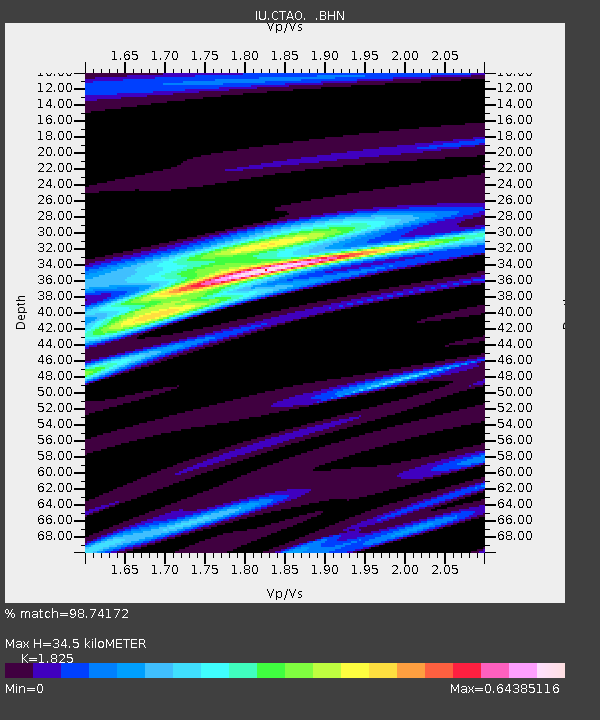
| Estimated Moho Depth: |
34.5 km |
| Estimated Crust Vp/Vs: |
1.83 |
| Assumed Crust Vp: |
6.522 km/s |
| Estimated Crust Vs: |
3.573 km/s |
| Estimated Crust Poisson's Ratio: |
0.29 |
|
| Radial Match: |
98.74172 % |
| Radial Bump: |
334 |
| Transverse Match: |
86.59697 % |
| Transverse Bump: |
400 |
| SOD ConfigId: |
16938 |
| Insert Time: |
2010-03-03 14:18:56.994 +0000 |
| GWidth: |
2.5 |
| Max Bumps: |
400 |
| Tol: |
0.001 |
|

Signal To Noise
| Channel | StoN | STA | LTA |
| IU:CTAO: :BHN:19930115T11:15:52.077026Z | 21.575201 | 1.2104592E-5 | 5.6104193E-7 |
| IU:CTAO: :BHE:19930115T11:15:52.075012Z | 1.3828226 | 1.6604504E-7 | 1.2007689E-7 |
| IU:CTAO: :BHZ:19930115T11:15:52.075012Z | 28.006056 | 2.735721E-5 | 9.76832E-7 |
| Arrivals |
| Ps | 4.6 SECOND |
| PpPs | 14 SECOND |
| PsPs/PpSs | 19 SECOND |


