You are here: Home > Network List > TA - USArray Transportable Network (new EarthScope stations) Stations List
> Station O48A Farmland, IN, USA > Earthquake Result Viewer
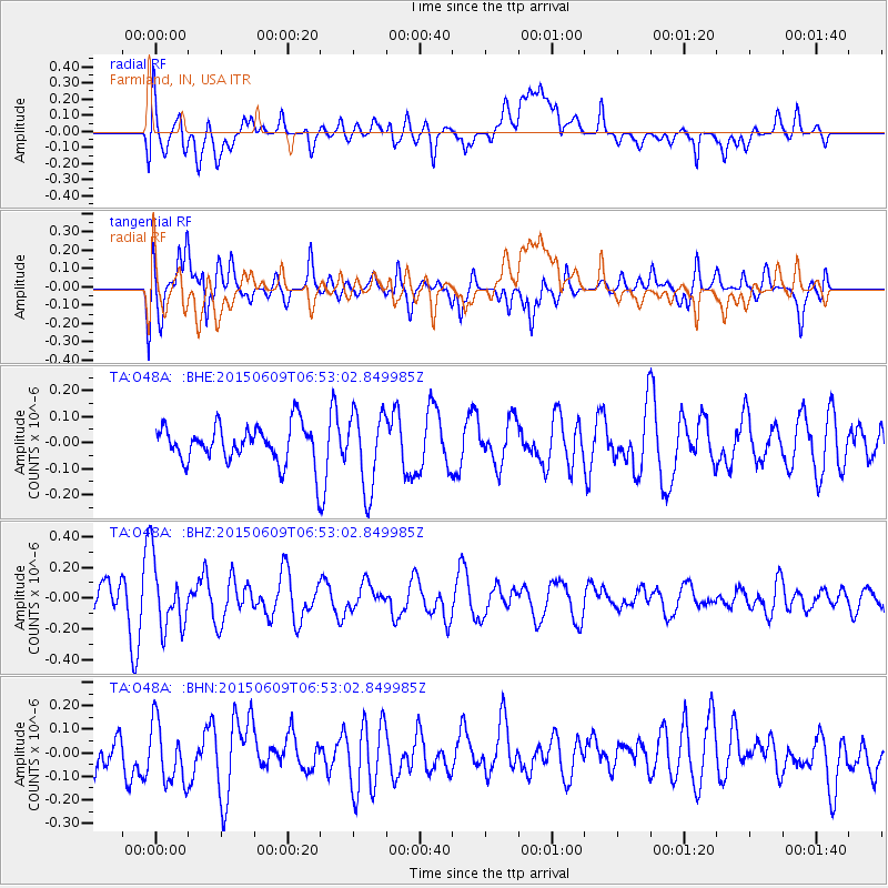
O48A Farmland, IN, USA - Earthquake Result Viewer
*The percent match for this event was below the threshold and hence no stack was calculated.
| Earthquake location: |
Southern East Pacific Rise |
| Earthquake latitude/longitude: |
-35.4/-105.8 |
| Earthquake time(UTC): |
2015/06/09 (160) 06:41:38 GMT |
| Earthquake Depth: |
10 km |
| Earthquake Magnitude: |
5.5 MWC, 5.4 MWB, 5.5 MWC |
| Earthquake Catalog/Contributor: |
NEIC PDE/NEIC COMCAT |
|
| Network: |
TA USArray Transportable Network (new EarthScope stations) |
| Station: |
O48A Farmland, IN, USA |
| Lat/Lon: |
40.26 N/85.16 W |
| Elevation: |
300 m |
|
| Distance: |
77.6 deg |
| Az: |
16.044 deg |
| Baz: |
197.165 deg |
| Ray Param: |
$rayparam |
*The percent match for this event was below the threshold and hence was not used in the summary stack. |
|
| Radial Match: |
53.925232 % |
| Radial Bump: |
400 |
| Transverse Match: |
64.91126 % |
| Transverse Bump: |
400 |
| SOD ConfigId: |
7422571 |
| Insert Time: |
2019-04-19 06:23:41.032 +0000 |
| GWidth: |
2.5 |
| Max Bumps: |
400 |
| Tol: |
0.001 |
|
Signal To Noise
| Channel | StoN | STA | LTA |
| TA:O48A: :BHZ:20150609T06:53:02.849985Z | 2.0661592 | 2.1542127E-7 | 1.042617E-7 |
| TA:O48A: :BHN:20150609T06:53:02.849985Z | 1.1318356 | 1.387036E-7 | 1.2254748E-7 |
| TA:O48A: :BHE:20150609T06:53:02.849985Z | 1.7551364 | 1.481635E-7 | 8.441708E-8 |
| Arrivals |
| Ps | |
| PpPs | |
| PsPs/PpSs | |


