You are here: Home > Network List > TA - USArray Transportable Network (new EarthScope stations) Stations List
> Station TPFO Pinon Flats, CA, USA > Earthquake Result Viewer
TPFO Pinon Flats, CA, USA - Earthquake Result Viewer
*The percent match for this event was below the threshold and hence no stack was calculated.
| Earthquake location: |
Southern East Pacific Rise |
| Earthquake latitude/longitude: |
-35.4/-105.8 |
| Earthquake time(UTC): |
2015/06/09 (160) 06:41:38 GMT |
| Earthquake Depth: |
10 km |
| Earthquake Magnitude: |
5.5 MWC, 5.4 MWB, 5.5 MWC |
| Earthquake Catalog/Contributor: |
NEIC PDE/NEIC COMCAT |
|
| Network: |
TA USArray Transportable Network (new EarthScope stations) |
| Station: |
TPFO Pinon Flats, CA, USA |
| Lat/Lon: |
33.61 N/116.45 W |
| Elevation: |
1275 m |
|
| Distance: |
69.3 deg |
| Az: |
350.518 deg |
| Baz: |
170.717 deg |
| Ray Param: |
$rayparam |
*The percent match for this event was below the threshold and hence was not used in the summary stack. |
|
| Radial Match: |
92.79573 % |
| Radial Bump: |
232 |
| Transverse Match: |
79.6572 % |
| Transverse Bump: |
261 |
| SOD ConfigId: |
7422571 |
| Insert Time: |
2019-04-19 06:23:43.144 +0000 |
| GWidth: |
2.5 |
| Max Bumps: |
400 |
| Tol: |
0.001 |
|
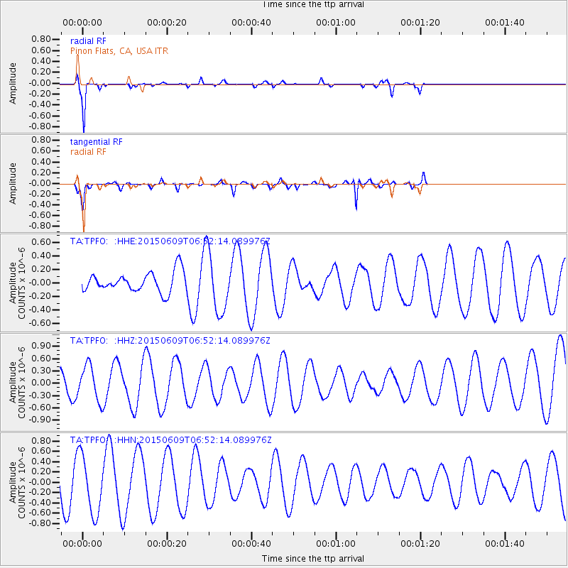
Signal To Noise
| Channel | StoN | STA | LTA |
| TA:TPFO: :HHZ:20150609T06:52:14.089976Z | 2.1265857 | 4.3210318E-7 | 2.0319105E-7 |
| TA:TPFO: :HHN:20150609T06:52:14.089976Z | 1.7752488 | 5.638173E-7 | 3.1759905E-7 |
| TA:TPFO: :HHE:20150609T06:52:14.089976Z | 2.246565 | 3.7422714E-7 | 1.6657746E-7 |
| Arrivals |
| Ps | |
| PpPs | |
| PsPs/PpSs | |


