You are here: Home > Network List > TA - USArray Transportable Network (new EarthScope stations) Stations List
> Station X43A Marvell, AR, USA > Earthquake Result Viewer
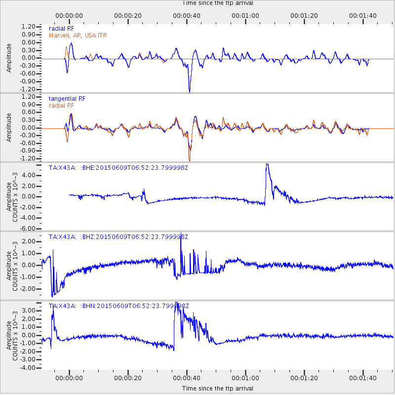
X43A Marvell, AR, USA - Earthquake Result Viewer
*The percent match for this event was below the threshold and hence no stack was calculated.
| Earthquake location: |
Southern East Pacific Rise |
| Earthquake latitude/longitude: |
-35.4/-105.8 |
| Earthquake time(UTC): |
2015/06/09 (160) 06:41:38 GMT |
| Earthquake Depth: |
10 km |
| Earthquake Magnitude: |
5.5 MWC, 5.4 MWB, 5.5 MWC |
| Earthquake Catalog/Contributor: |
NEIC PDE/NEIC COMCAT |
|
| Network: |
TA USArray Transportable Network (new EarthScope stations) |
| Station: |
X43A Marvell, AR, USA |
| Lat/Lon: |
34.52 N/90.88 W |
| Elevation: |
53 m |
|
| Distance: |
70.9 deg |
| Az: |
13.009 deg |
| Baz: |
192.872 deg |
| Ray Param: |
$rayparam |
*The percent match for this event was below the threshold and hence was not used in the summary stack. |
|
| Radial Match: |
80.61682 % |
| Radial Bump: |
400 |
| Transverse Match: |
78.292946 % |
| Transverse Bump: |
400 |
| SOD ConfigId: |
7422571 |
| Insert Time: |
2019-04-19 06:23:45.407 +0000 |
| GWidth: |
2.5 |
| Max Bumps: |
400 |
| Tol: |
0.001 |
|
Signal To Noise
| Channel | StoN | STA | LTA |
| TA:X43A: :BHZ:20150609T06:52:23.799998Z | 1.7852708 | 0.0011377257 | 6.3728465E-4 |
| TA:X43A: :BHN:20150609T06:52:23.799998Z | 0.7995589 | 4.6925055E-4 | 5.8688683E-4 |
| TA:X43A: :BHE:20150609T06:52:23.799998Z | 3.2478273 | 8.6148997E-4 | 2.6525115E-4 |
| Arrivals |
| Ps | |
| PpPs | |
| PsPs/PpSs | |


