You are here: Home > Network List > IU - Global Seismograph Network (GSN - IRIS/USGS) Stations List
> Station CTAO Charters Towers, Australia > Earthquake Result Viewer
CTAO Charters Towers, Australia - Earthquake Result Viewer
| Earthquake location: |
Mariana Islands |
| Earthquake latitude/longitude: |
15.7/146.6 |
| Earthquake time(UTC): |
1993/06/06 (157) 13:23:27 GMT |
| Earthquake Depth: |
68 km |
| Earthquake Magnitude: |
5.8 MB, 6.4 UNKNOWN |
| Earthquake Catalog/Contributor: |
WHDF/NEIC |
|
| Network: |
IU Global Seismograph Network (GSN - IRIS/USGS) |
| Station: |
CTAO Charters Towers, Australia |
| Lat/Lon: |
20.09 S/146.25 E |
| Elevation: |
357 m |
|
| Distance: |
35.5 deg |
| Az: |
180.52 deg |
| Baz: |
0.533 deg |
| Ray Param: |
0.07696896 |
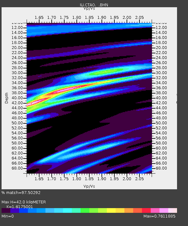
| Estimated Moho Depth: |
42.0 km |
| Estimated Crust Vp/Vs: |
1.62 |
| Assumed Crust Vp: |
6.522 km/s |
| Estimated Crust Vs: |
4.032 km/s |
| Estimated Crust Poisson's Ratio: |
0.19 |
|
| Radial Match: |
97.50292 % |
| Radial Bump: |
168 |
| Transverse Match: |
80.33681 % |
| Transverse Bump: |
400 |
| SOD ConfigId: |
16938 |
| Insert Time: |
2010-03-03 14:19:32.568 +0000 |
| GWidth: |
2.5 |
| Max Bumps: |
400 |
| Tol: |
0.001 |
|
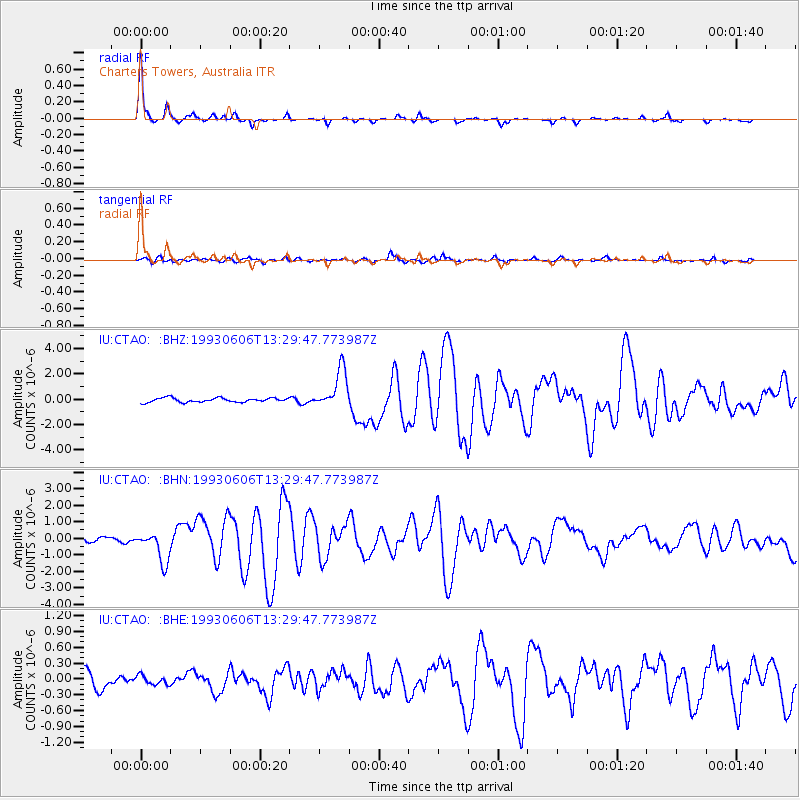
Signal To Noise
| Channel | StoN | STA | LTA |
| IU:CTAO: :BHN:19930606T13:29:47.773987Z | 9.126287 | 9.3402434E-7 | 1.0234439E-7 |
| IU:CTAO: :BHE:19930606T13:29:47.773987Z | 0.6873417 | 8.7026805E-8 | 1.266136E-7 |
| IU:CTAO: :BHZ:19930606T13:29:47.773987Z | 9.071921 | 1.5424862E-6 | 1.7002861E-7 |
| Arrivals |
| Ps | 4.3 SECOND |
| PpPs | 15 SECOND |
| PsPs/PpSs | 20 SECOND |


