You are here: Home > Network List > GS - US Geological Survey Networks Stations List
> Station KAN13 Rinehart Farm > Earthquake Result Viewer
KAN13 Rinehart Farm - Earthquake Result Viewer
*The percent match for this event was below the threshold and hence no stack was calculated.
| Earthquake location: |
South Of Fiji Islands |
| Earthquake latitude/longitude: |
-24.0/-176.3 |
| Earthquake time(UTC): |
2015/06/09 (160) 18:43:27 GMT |
| Earthquake Depth: |
82 km |
| Earthquake Magnitude: |
5.0 mb |
| Earthquake Catalog/Contributor: |
ISC/ISC |
|
| Network: |
GS US Geological Survey Networks |
| Station: |
KAN13 Rinehart Farm |
| Lat/Lon: |
37.01 N/97.48 W |
| Elevation: |
340 m |
|
| Distance: |
95.8 deg |
| Az: |
52.125 deg |
| Baz: |
244.383 deg |
| Ray Param: |
$rayparam |
*The percent match for this event was below the threshold and hence was not used in the summary stack. |
|
| Radial Match: |
62.92395 % |
| Radial Bump: |
400 |
| Transverse Match: |
71.40828 % |
| Transverse Bump: |
400 |
| SOD ConfigId: |
7422571 |
| Insert Time: |
2019-04-19 06:27:41.665 +0000 |
| GWidth: |
2.5 |
| Max Bumps: |
400 |
| Tol: |
0.001 |
|
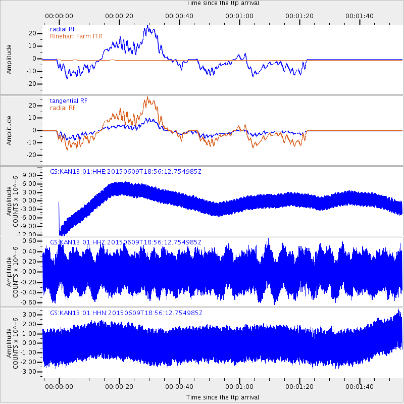
Signal To Noise
| Channel | StoN | STA | LTA |
| GS:KAN13:01:HHZ:20150609T18:56:12.754985Z | 1.0468267 | 3.1523638E-7 | 3.0113517E-7 |
| GS:KAN13:01:HHN:20150609T18:56:12.754985Z | 1.09732 | 1.4125981E-6 | 1.2873164E-6 |
| GS:KAN13:01:HHE:20150609T18:56:12.754985Z | 0.7568658 | 4.140571E-6 | 5.470681E-6 |
| Arrivals |
| Ps | |
| PpPs | |
| PsPs/PpSs | |


