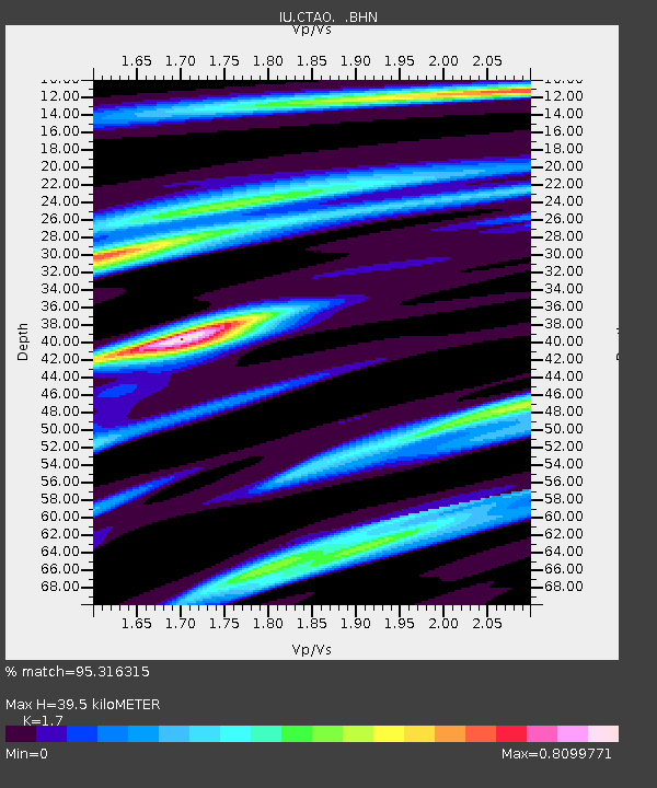
CTAO Charters Towers, Australia - Earthquake Result Viewer

Earthquake location: Off W. Coast Of S. Island, N.Z.
Earthquake latitude/longitude: -45.1/167.0
Earthquake time(UTC): 1993/08/10 (222) 00:51:54 GMT
Earthquake Depth: 33 km
Earthquake Magnitude: 6.2 MB, 7.1 MS, 7.1 UNKNOWN, 7.0 MW
Earthquake Catalog/Contributor: WHDF/NEIC
Network: IU Global Seismograph Network (GSN - IRIS/USGS)
Station: CTAO Charters Towers, Australia
Lat/Lon: 20.09 S/146.25 E
Elevation: 357 m
Distance: 30.3 deg
Az: 318.799 deg
Baz: 150.264 deg
Ray Param: 0.07934015
Estimated Moho Depth: 39.5 km
Estimated Crust Vp/Vs: 1.70
Assumed Crust Vp: 6.522 km/s
Estimated Crust Vs: 3.836 km/s
Estimated Crust Poisson's Ratio: 0.24
Radial Match: 95.316315 %
Radial Bump: 285
Transverse Match: 71.35318 %
Transverse Bump: 400
SOD ConfigId: 16938
Insert Time: 2010-03-03 14:19:57.864 +0000
GWidth: 2.5
Max Bumps: 400
Tol: 0.001

Signal To Noise

ChannelStoNSTALTA
IU:CTAO: :BHN:19930810T00:57:32.575Z4.20127348.465629E-72.015015E-7
IU:CTAO: :BHE:19930810T00:57:32.575Z2.41534354.848151E-72.0072305E-7
IU:CTAO: :BHZ:19930810T00:57:32.575Z4.18645141.382105E-63.301376E-7
Arrivals
Ps4.6 SECOND
PpPs15 SECOND
PsPs/PpSs20 SECOND