You are here: Home > Network List > TA - USArray Transportable Network (new EarthScope stations) Stations List
> Station WHTX Lake Whitney, Meridian, TX, USA > Earthquake Result Viewer
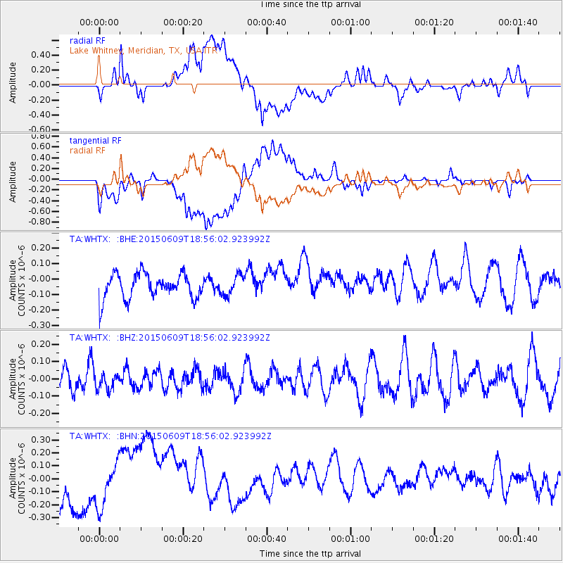
WHTX Lake Whitney, Meridian, TX, USA - Earthquake Result Viewer
*The percent match for this event was below the threshold and hence no stack was calculated.
| Earthquake location: |
South Of Fiji Islands |
| Earthquake latitude/longitude: |
-24.0/-176.3 |
| Earthquake time(UTC): |
2015/06/09 (160) 18:43:27 GMT |
| Earthquake Depth: |
82 km |
| Earthquake Magnitude: |
5.0 mb |
| Earthquake Catalog/Contributor: |
ISC/ISC |
|
| Network: |
TA USArray Transportable Network (new EarthScope stations) |
| Station: |
WHTX Lake Whitney, Meridian, TX, USA |
| Lat/Lon: |
31.99 N/97.46 W |
| Elevation: |
190 m |
|
| Distance: |
93.6 deg |
| Az: |
56.658 deg |
| Baz: |
244.022 deg |
| Ray Param: |
$rayparam |
*The percent match for this event was below the threshold and hence was not used in the summary stack. |
|
| Radial Match: |
37.761757 % |
| Radial Bump: |
400 |
| Transverse Match: |
36.572273 % |
| Transverse Bump: |
400 |
| SOD ConfigId: |
7422571 |
| Insert Time: |
2019-04-19 06:29:34.112 +0000 |
| GWidth: |
2.5 |
| Max Bumps: |
400 |
| Tol: |
0.001 |
|
Signal To Noise
| Channel | StoN | STA | LTA |
| TA:WHTX: :BHZ:20150609T18:56:02.923992Z | 0.58216643 | 4.7088413E-8 | 8.0884796E-8 |
| TA:WHTX: :BHN:20150609T18:56:02.923992Z | 1.6417688 | 1.9633194E-7 | 1.1958562E-7 |
| TA:WHTX: :BHE:20150609T18:56:02.923992Z | 0.83215517 | 6.6234264E-8 | 7.959365E-8 |
| Arrivals |
| Ps | |
| PpPs | |
| PsPs/PpSs | |


