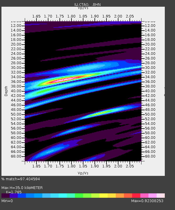
CTAO Charters Towers, Australia - Earthquake Result Viewer

Earthquake location: Off East Coast Of Honshu, Japan
Earthquake latitude/longitude: 40.5/143.5
Earthquake time(UTC): 1994/12/28 (362) 12:19:23 GMT
Earthquake Depth: 33 km
Earthquake Magnitude: 6.4 MB, 7.5 MS, 7.2 UNKNOWN, 7.7 MW
Earthquake Catalog/Contributor: WHDF/NEIC
Network: IU Global Seismograph Network (GSN - IRIS/USGS)
Station: CTAO Charters Towers, Australia
Lat/Lon: 20.09 S/146.25 E
Elevation: 357 m
Distance: 60.3 deg
Az: 177.009 deg
Baz: 357.572 deg
Ray Param: 0.061579667
Estimated Moho Depth: 35.0 km
Estimated Crust Vp/Vs: 1.76
Assumed Crust Vp: 6.522 km/s
Estimated Crust Vs: 3.695 km/s
Estimated Crust Poisson's Ratio: 0.26
Radial Match: 97.404594 %
Radial Bump: 243
Transverse Match: 83.851456 %
Transverse Bump: 400
SOD ConfigId: 16938
Insert Time: 2010-03-03 14:21:27.487 +0000
GWidth: 2.5
Max Bumps: 400
Tol: 0.001

Signal To Noise

ChannelStoNSTALTA
IU:CTAO: :BHN:19941228T12:28:58.125024Z2.16043573.4958973E-71.6181446E-7
IU:CTAO: :BHE:19941228T12:28:58.125024Z0.84279521.5134567E-71.7957588E-7
IU:CTAO: :BHZ:19941228T12:28:58.125024Z1.15693142.8015194E-72.4215086E-7
Arrivals
Ps4.3 SECOND
PpPs14 SECOND
PsPs/PpSs18 SECOND