You are here: Home > Network List > IU - Global Seismograph Network (GSN - IRIS/USGS) Stations List
> Station CTAO Charters Towers, Australia > Earthquake Result Viewer
CTAO Charters Towers, Australia - Earthquake Result Viewer
| Earthquake location: |
Samar, Philippines |
| Earthquake latitude/longitude: |
12.4/125.4 |
| Earthquake time(UTC): |
1995/04/23 (113) 05:08:03 GMT |
| Earthquake Depth: |
33 km |
| Earthquake Magnitude: |
6.0 MB, 6.6 MS, 6.7 UNKNOWN, 6.7 MW |
| Earthquake Catalog/Contributor: |
WHDF/NEIC |
|
| Network: |
IU Global Seismograph Network (GSN - IRIS/USGS) |
| Station: |
CTAO Charters Towers, Australia |
| Lat/Lon: |
20.09 S/146.25 E |
| Elevation: |
357 m |
|
| Distance: |
38.3 deg |
| Az: |
147.228 deg |
| Baz: |
325.758 deg |
| Ray Param: |
0.07560327 |
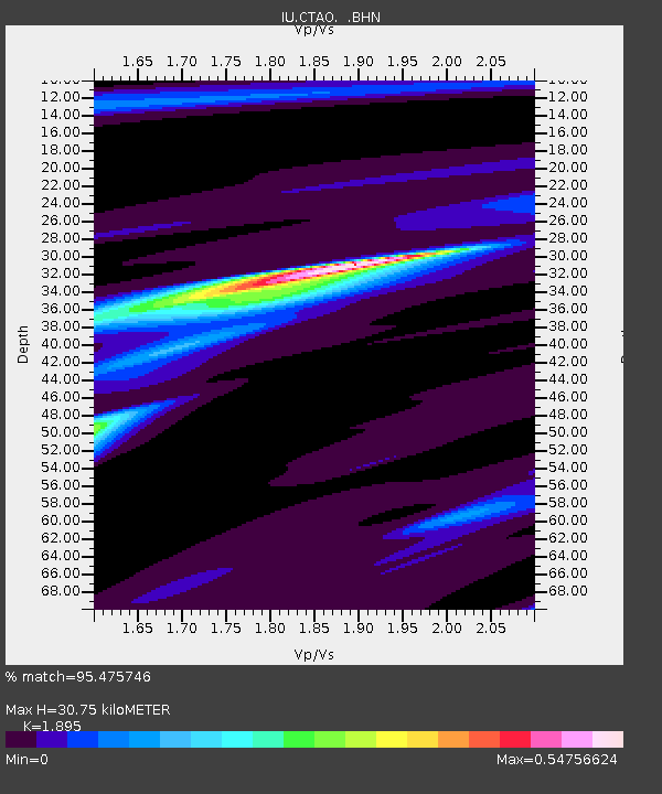
| Estimated Moho Depth: |
30.75 km |
| Estimated Crust Vp/Vs: |
1.89 |
| Assumed Crust Vp: |
6.522 km/s |
| Estimated Crust Vs: |
3.441 km/s |
| Estimated Crust Poisson's Ratio: |
0.31 |
|
| Radial Match: |
95.475746 % |
| Radial Bump: |
115 |
| Transverse Match: |
52.289158 % |
| Transverse Bump: |
400 |
| SOD ConfigId: |
6273 |
| Insert Time: |
2010-03-03 14:22:25.677 +0000 |
| GWidth: |
2.5 |
| Max Bumps: |
400 |
| Tol: |
0.001 |
|

Signal To Noise
| Channel | StoN | STA | LTA |
| IU:CTAO: :BHN:19950423T05:14:49.825Z | 3.47338 | 7.9316914E-7 | 2.2835655E-7 |
| IU:CTAO: :BHE:19950423T05:14:49.825Z | 2.661605 | 5.768336E-7 | 2.1672399E-7 |
| IU:CTAO: :BHZ:19950423T05:14:49.825Z | 7.173464 | 1.8895036E-6 | 2.6340183E-7 |
| Arrivals |
| Ps | 4.5 SECOND |
| PpPs | 13 SECOND |
| PsPs/PpSs | 17 SECOND |


