You are here: Home > Network List > IU - Global Seismograph Network (GSN - IRIS/USGS) Stations List
> Station CTAO Charters Towers, Australia > Earthquake Result Viewer
CTAO Charters Towers, Australia - Earthquake Result Viewer

| Earthquake location: |
Balleny Islands Region |
| Earthquake latitude/longitude: |
-61.6/154.7 |
| Earthquake time(UTC): |
1995/06/21 (172) 15:28:51 GMT |
| Earthquake Depth: |
10 km |
| Earthquake Magnitude: |
5.6 MB, 6.7 MS, 6.8 UNKNOWN, 6.8 MW |
| Earthquake Catalog/Contributor: |
WHDF/NEIC |
|
| Network: |
IU Global Seismograph Network (GSN - IRIS/USGS) |
| Station: |
CTAO Charters Towers, Australia |
| Lat/Lon: |
20.09 S/146.25 E |
| Elevation: |
357 m |
|
| Distance: |
41.9 deg |
| Az: |
348.055 deg |
| Baz: |
173.961 deg |
| Ray Param: |
0.07348811 |
| Estimated Moho Depth: |
28.5 km |
| Estimated Crust Vp/Vs: |
1.62 |
| Assumed Crust Vp: |
6.522 km/s |
| Estimated Crust Vs: |
4.026 km/s |
| Estimated Crust Poisson's Ratio: |
0.19 |
|
| Radial Match: |
96.583534 % |
| Radial Bump: |
204 |
| Transverse Match: |
87.28478 % |
| Transverse Bump: |
400 |
| SOD ConfigId: |
6273 |
| Insert Time: |
2010-03-03 14:22:34.600 +0000 |
| GWidth: |
2.5 |
| Max Bumps: |
400 |
| Tol: |
0.001 |
|
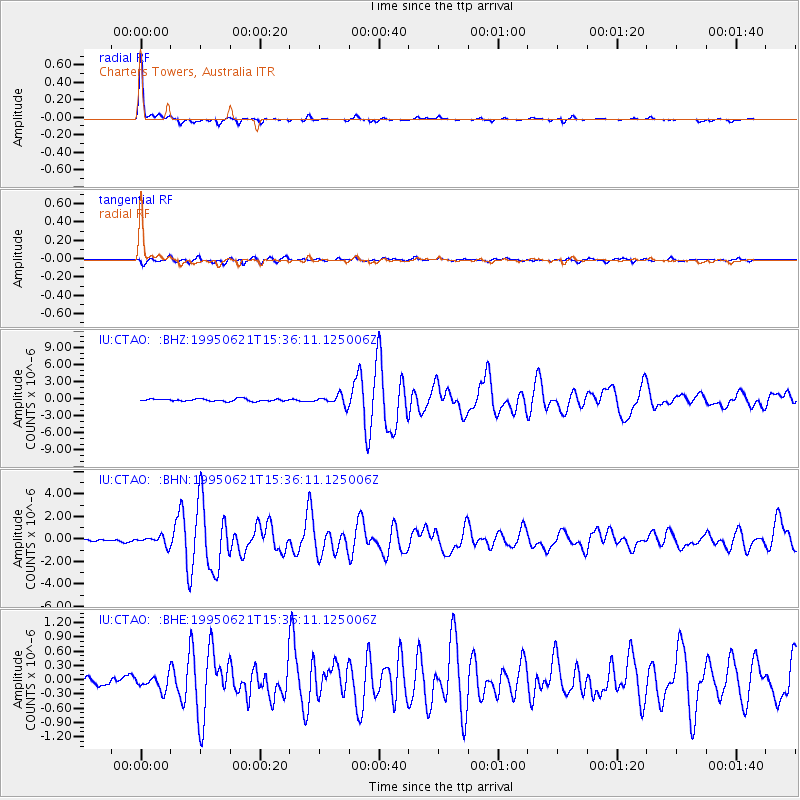
Signal To Noise
| Channel | StoN | STA | LTA |
| IU:CTAO: :BHN:19950621T15:36:11.125006Z | 2.9864554 | 3.882173E-7 | 1.2999267E-7 |
| IU:CTAO: :BHE:19950621T15:36:11.125006Z | 1.0287174 | 1.5403627E-7 | 1.4973624E-7 |
| IU:CTAO: :BHZ:19950621T15:36:11.125006Z | 4.3315673 | 8.592612E-7 | 1.983719E-7 |
| Arrivals |
| Ps | 2.9 SECOND |
| PpPs | 11 SECOND |
| PsPs/PpSs | 14 SECOND |


