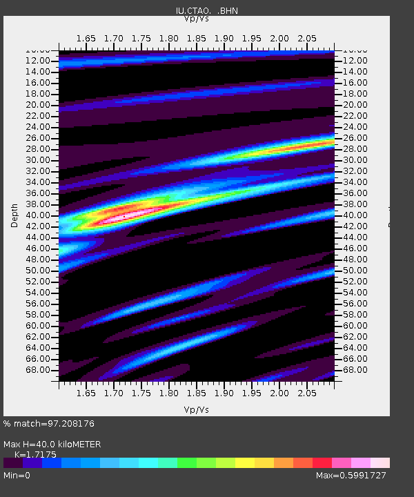
CTAO Charters Towers, Australia - Earthquake Result Viewer

Earthquake location: Off W Coast Of Northern Sumatra
Earthquake latitude/longitude: 1.9/95.1
Earthquake time(UTC): 1995/11/08 (312) 07:14:18 GMT
Earthquake Depth: 33 km
Earthquake Magnitude: 6.1 MB, 6.9 MS, 6.7 UNKNOWN, 6.9 MW
Earthquake Catalog/Contributor: WHDF/NEIC
Network: IU Global Seismograph Network (GSN - IRIS/USGS)
Station: CTAO Charters Towers, Australia
Lat/Lon: 20.09 S/146.25 E
Elevation: 357 m
Distance: 54.7 deg
Az: 116.186 deg
Baz: 287.399 deg
Ray Param: 0.06521902
Estimated Moho Depth: 40.0 km
Estimated Crust Vp/Vs: 1.72
Assumed Crust Vp: 6.522 km/s
Estimated Crust Vs: 3.797 km/s
Estimated Crust Poisson's Ratio: 0.24
Radial Match: 97.208176 %
Radial Bump: 289
Transverse Match: 88.31777 %
Transverse Bump: 400
SOD ConfigId: 6273
Insert Time: 2010-03-03 14:22:47.595 +0000
GWidth: 2.5
Max Bumps: 400
Tol: 0.001

Signal To Noise

ChannelStoNSTALTA
IU:CTAO: :BHN:19951108T07:23:13.825012Z2.00651172.1521917E-71.0726037E-7
IU:CTAO: :BHE:19951108T07:23:13.825012Z4.90299464.1660408E-78.496931E-8
IU:CTAO: :BHZ:19951108T07:23:13.825012Z8.5356669.715266E-71.13819645E-7
Arrivals
Ps4.7 SECOND
PpPs16 SECOND
PsPs/PpSs20 SECOND