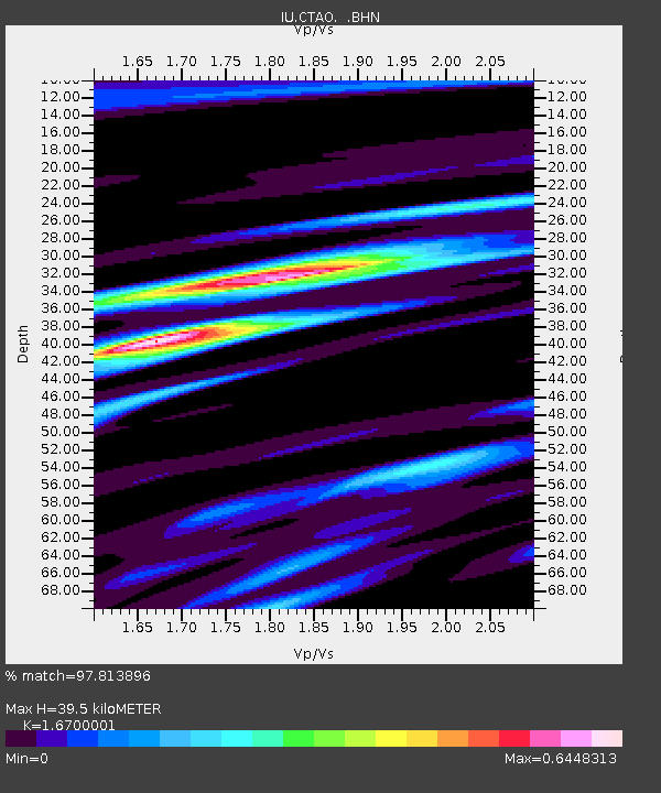
CTAO Charters Towers, Australia - Earthquake Result Viewer

Earthquake location: Andreanof Islands, Aleutian Is.
Earthquake latitude/longitude: 51.6/-177.6
Earthquake time(UTC): 1996/06/10 (162) 04:03:35 GMT
Earthquake Depth: 33 km
Earthquake Magnitude: 6.6 MB, 7.6 MS, 7.9 UNKNOWN, 7.4 MS
Earthquake Catalog/Contributor: WHDF/NEIC
Network: IU Global Seismograph Network (GSN - IRIS/USGS)
Station: CTAO Charters Towers, Australia
Lat/Lon: 20.09 S/146.25 E
Elevation: 357 m
Distance: 78.0 deg
Az: 214.49 deg
Baz: 22.09 deg
Ray Param: 0.04986558
Estimated Moho Depth: 39.5 km
Estimated Crust Vp/Vs: 1.67
Assumed Crust Vp: 6.522 km/s
Estimated Crust Vs: 3.905 km/s
Estimated Crust Poisson's Ratio: 0.22
Radial Match: 97.813896 %
Radial Bump: 372
Transverse Match: 89.57771 %
Transverse Bump: 400
SOD ConfigId: 6273
Insert Time: 2010-03-03 14:23:07.594 +0000
GWidth: 2.5
Max Bumps: 400
Tol: 0.001

Signal To Noise

ChannelStoNSTALTA
IU:CTAO: :BHN:19960610T04:14:59.623999Z11.3560221.7065021E-61.5027288E-7
IU:CTAO: :BHE:19960610T04:14:59.623999Z4.7041395.6366514E-71.1982323E-7
IU:CTAO: :BHZ:19960610T04:14:59.623022Z30.6743074.6520217E-61.5165858E-7
Arrivals
Ps4.2 SECOND
PpPs16 SECOND
PsPs/PpSs20 SECOND