You are here: Home > Network List > IU - Global Seismograph Network (GSN - IRIS/USGS) Stations List
> Station CTAO Charters Towers, Australia > Earthquake Result Viewer
CTAO Charters Towers, Australia - Earthquake Result Viewer

| Earthquake location: |
Fiji Islands Region |
| Earthquake latitude/longitude: |
-20.7/-178.3 |
| Earthquake time(UTC): |
1996/08/05 (218) 22:38:22 GMT |
| Earthquake Depth: |
550 km |
| Earthquake Magnitude: |
6.4 MB, 7.4 UNKNOWN, 7.3 MW |
| Earthquake Catalog/Contributor: |
WHDF/NEIC |
|
| Network: |
IU Global Seismograph Network (GSN - IRIS/USGS) |
| Station: |
CTAO Charters Towers, Australia |
| Lat/Lon: |
20.09 S/146.25 E |
| Elevation: |
357 m |
|
| Distance: |
33.2 deg |
| Az: |
264.685 deg |
| Baz: |
97.313 deg |
| Ray Param: |
0.075734034 |
| Estimated Moho Depth: |
30.25 km |
| Estimated Crust Vp/Vs: |
1.90 |
| Assumed Crust Vp: |
6.522 km/s |
| Estimated Crust Vs: |
3.423 km/s |
| Estimated Crust Poisson's Ratio: |
0.31 |
|
| Radial Match: |
94.92201 % |
| Radial Bump: |
177 |
| Transverse Match: |
73.985115 % |
| Transverse Bump: |
400 |
| SOD ConfigId: |
6273 |
| Insert Time: |
2010-03-03 14:23:35.627 +0000 |
| GWidth: |
2.5 |
| Max Bumps: |
400 |
| Tol: |
0.001 |
|
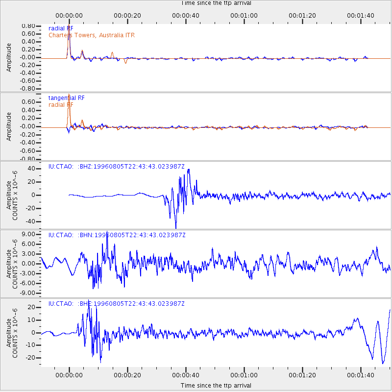
Signal To Noise
| Channel | StoN | STA | LTA |
| IU:CTAO: :BHN:19960805T22:43:43.023987Z | 1.8667583 | 2.092561E-6 | 1.1209598E-6 |
| IU:CTAO: :BHE:19960805T22:43:43.023987Z | 4.9911304 | 4.39212E-6 | 8.79985E-7 |
| IU:CTAO: :BHZ:19960805T22:43:43.023987Z | 6.540431 | 1.0108181E-5 | 1.5454916E-6 |
| Arrivals |
| Ps | 4.5 SECOND |
| PpPs | 13 SECOND |
| PsPs/PpSs | 17 SECOND |


