You are here: Home > Network List > 7A - Mid-Atlantic Geophysical Integrative Collaboration Stations List
> Station PETO Lost Creek, West Virginia USA > Earthquake Result Viewer
PETO Lost Creek, West Virginia USA - Earthquake Result Viewer
| Earthquake location: |
Northern Chile |
| Earthquake latitude/longitude: |
-22.4/-68.3 |
| Earthquake time(UTC): |
2015/06/10 (161) 13:52:08 GMT |
| Earthquake Depth: |
122 km |
| Earthquake Magnitude: |
6.0 MO |
| Earthquake Catalog/Contributor: |
NEIC PDE/NEIC ALERT |
|
| Network: |
7A Mid-Atlantic Geophysical Integrative Collaboration |
| Station: |
PETO Lost Creek, West Virginia USA |
| Lat/Lon: |
39.16 N/80.33 W |
| Elevation: |
0.0 m |
|
| Distance: |
62.3 deg |
| Az: |
349.478 deg |
| Baz: |
167.446 deg |
| Ray Param: |
0.05998882 |
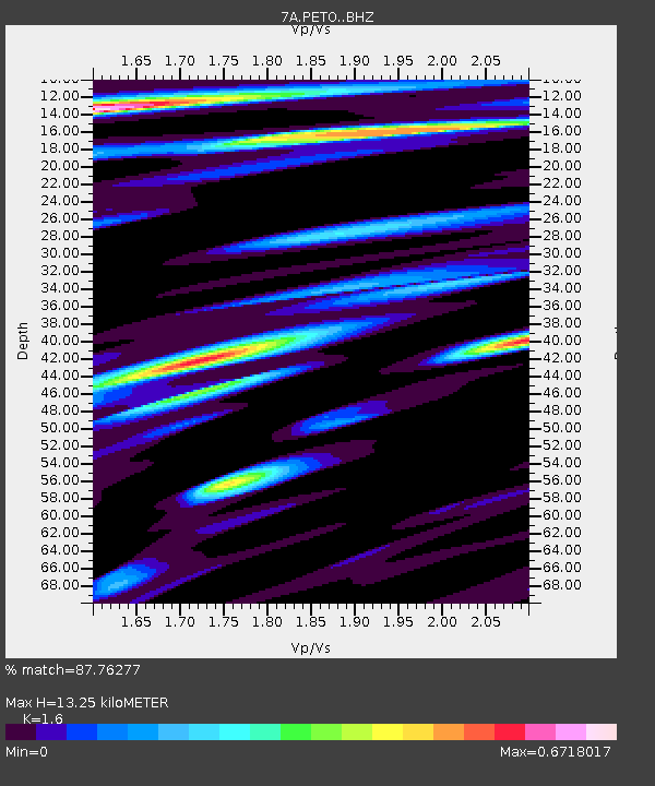
| Estimated Moho Depth: |
13.25 km |
| Estimated Crust Vp/Vs: |
1.60 |
| Assumed Crust Vp: |
6.207 km/s |
| Estimated Crust Vs: |
3.879 km/s |
| Estimated Crust Poisson's Ratio: |
0.18 |
|
| Radial Match: |
87.76277 % |
| Radial Bump: |
400 |
| Transverse Match: |
80.48358 % |
| Transverse Bump: |
400 |
| SOD ConfigId: |
7422571 |
| Insert Time: |
2019-04-19 06:53:24.747 +0000 |
| GWidth: |
2.5 |
| Max Bumps: |
400 |
| Tol: |
0.001 |
|

Signal To Noise
| Channel | StoN | STA | LTA |
| 7A:PETO: :BHZ:20150610T14:01:46.849988Z | 11.291057 | 1.4998548E-6 | 1.3283564E-7 |
| 7A:PETO: :BHN:20150610T14:01:46.849988Z | 4.6572795 | 4.687717E-7 | 1.00653544E-7 |
| 7A:PETO: :BHE:20150610T14:01:46.849988Z | 1.5965054 | 1.6960686E-7 | 1.0623632E-7 |
| Arrivals |
| Ps | 1.3 SECOND |
| PpPs | 5.3 SECOND |
| PsPs/PpSs | 6.6 SECOND |


