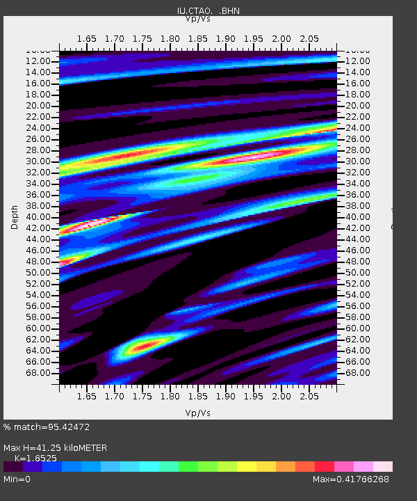
CTAO Charters Towers, Australia - Earthquake Result Viewer
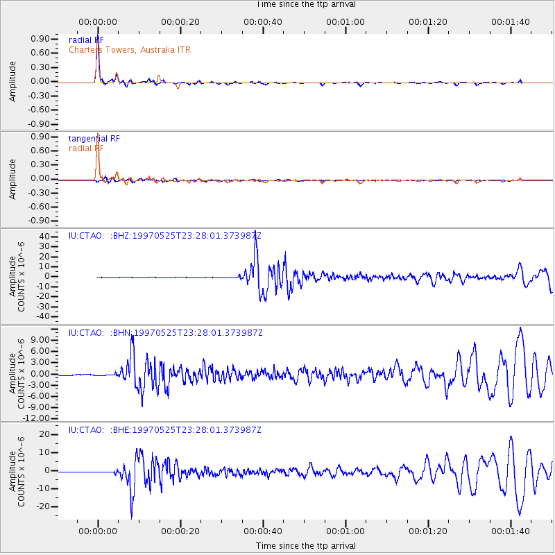
Earthquake location: South Of Kermadec Islands
Earthquake latitude/longitude: -32.1/179.8
Earthquake time(UTC): 1997/05/25 (145) 23:22:33 GMT
Earthquake Depth: 333 km
Earthquake Magnitude: 6.2 MB, 7.1 UNKNOWN, 7.0 MW
Earthquake Catalog/Contributor: WHDF/NEIC
Network: IU Global Seismograph Network (GSN - IRIS/USGS)
Station: CTAO Charters Towers, Australia
Lat/Lon: 20.09 S/146.25 E
Elevation: 357 m
Distance: 32.3 deg
Az: 283.509 deg
Baz: 118.614 deg
Ray Param: 0.07752828
Estimated Moho Depth: 41.25 km
Estimated Crust Vp/Vs: 1.65
Assumed Crust Vp: 6.522 km/s
Estimated Crust Vs: 3.947 km/s
Estimated Crust Poisson's Ratio: 0.21
Radial Match: 95.42472 %
Radial Bump: 228
Transverse Match: 72.88485 %
Transverse Bump: 400
SOD ConfigId: 6273
Insert Time: 2010-03-03 14:24:14.360 +0000
GWidth: 2.5
Max Bumps: 400
Tol: 0.001

Signal To Noise

ChannelStoNSTALTA
IU:CTAO: :BHN:19970525T23:28:01.373987Z1.04509682.0565612E-71.967819E-7
IU:CTAO: :BHE:19970525T23:28:01.373987Z3.63728573.935649E-71.08202904E-7
IU:CTAO: :BHZ:19970525T23:28:01.373987Z3.11645727.67462E-72.4626104E-7
Arrivals
Ps4.5 SECOND
PpPs15 SECOND
PsPs/PpSs20 SECOND