You are here: Home > Network List > IW - Intermountain West Stations List
> Station MOOW Moose Ponds, Wyoming, USA > Earthquake Result Viewer
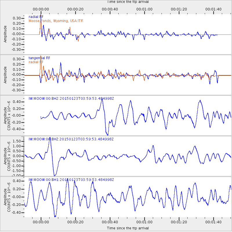
MOOW Moose Ponds, Wyoming, USA - Earthquake Result Viewer
*The percent match for this event was below the threshold and hence no stack was calculated.
| Earthquake location: |
Vanuatu Islands |
| Earthquake latitude/longitude: |
-17.0/168.5 |
| Earthquake time(UTC): |
2015/01/23 (023) 03:47:27 GMT |
| Earthquake Depth: |
218 km |
| Earthquake Magnitude: |
6.8 MWP, 6.9 MI, 7.0 MI |
| Earthquake Catalog/Contributor: |
NEIC PDE/NEIC COMCAT |
|
| Network: |
IW Intermountain West |
| Station: |
MOOW Moose Ponds, Wyoming, USA |
| Lat/Lon: |
43.75 N/110.74 W |
| Elevation: |
2128 m |
|
| Distance: |
95.1 deg |
| Az: |
45.892 deg |
| Baz: |
251.451 deg |
| Ray Param: |
$rayparam |
*The percent match for this event was below the threshold and hence was not used in the summary stack. |
|
| Radial Match: |
74.70433 % |
| Radial Bump: |
400 |
| Transverse Match: |
67.73922 % |
| Transverse Bump: |
400 |
| SOD ConfigId: |
837871 |
| Insert Time: |
2015-02-06 04:01:35.788 +0000 |
| GWidth: |
2.5 |
| Max Bumps: |
400 |
| Tol: |
0.001 |
|
Signal To Noise
| Channel | StoN | STA | LTA |
| IW:MOOW:00:BHZ:20150123T03:59:53.484998Z | 6.5160723 | 5.6152874E-7 | 8.617595E-8 |
| IW:MOOW:00:BH1:20150123T03:59:53.484998Z | 0.8397037 | 1.5024152E-7 | 1.7892208E-7 |
| IW:MOOW:00:BH2:20150123T03:59:53.484998Z | 2.3953958 | 1.5376658E-7 | 6.4192555E-8 |
| Arrivals |
| Ps | |
| PpPs | |
| PsPs/PpSs | |


