You are here: Home > Network List > CI - Caltech Regional Seismic Network Stations List
> Station SWS Sam W. Stewart, Westmorland, CA, USA > Earthquake Result Viewer
SWS Sam W. Stewart, Westmorland, CA, USA - Earthquake Result Viewer
| Earthquake location: |
Northern Chile |
| Earthquake latitude/longitude: |
-22.4/-68.3 |
| Earthquake time(UTC): |
2015/06/10 (161) 13:52:08 GMT |
| Earthquake Depth: |
122 km |
| Earthquake Magnitude: |
6.0 MO |
| Earthquake Catalog/Contributor: |
NEIC PDE/NEIC ALERT |
|
| Network: |
CI Caltech Regional Seismic Network |
| Station: |
SWS Sam W. Stewart, Westmorland, CA, USA |
| Lat/Lon: |
32.94 N/115.80 W |
| Elevation: |
140 m |
|
| Distance: |
71.3 deg |
| Az: |
319.138 deg |
| Baz: |
133.949 deg |
| Ray Param: |
0.054119345 |
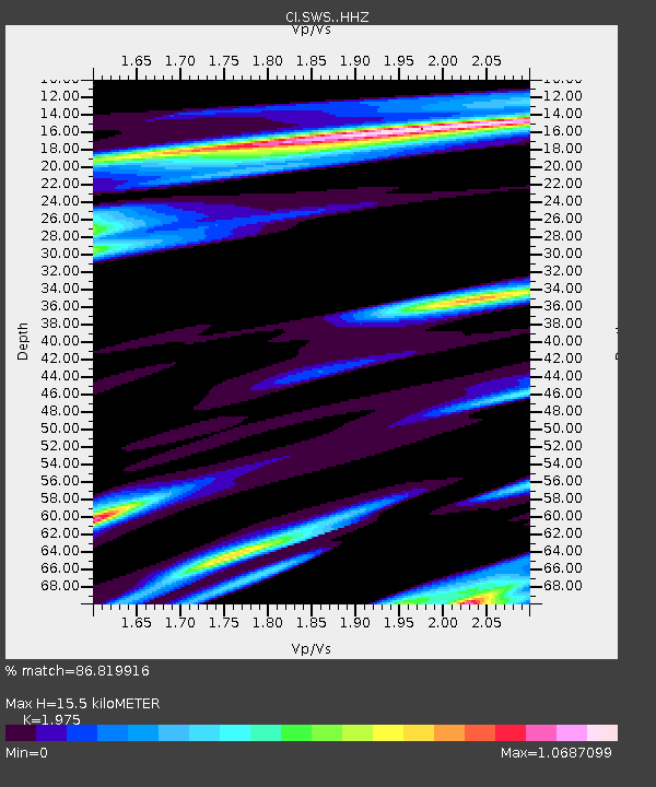
| Estimated Moho Depth: |
15.5 km |
| Estimated Crust Vp/Vs: |
1.98 |
| Assumed Crust Vp: |
6.155 km/s |
| Estimated Crust Vs: |
3.116 km/s |
| Estimated Crust Poisson's Ratio: |
0.33 |
|
| Radial Match: |
86.819916 % |
| Radial Bump: |
361 |
| Transverse Match: |
79.780655 % |
| Transverse Bump: |
343 |
| SOD ConfigId: |
7422571 |
| Insert Time: |
2019-04-19 06:55:07.091 +0000 |
| GWidth: |
2.5 |
| Max Bumps: |
400 |
| Tol: |
0.001 |
|

Signal To Noise
| Channel | StoN | STA | LTA |
| CI:SWS: :HHZ:20150610T14:02:43.568005Z | 14.117669 | 1.4363324E-6 | 1.0174005E-7 |
| CI:SWS: :HHN:20150610T14:02:43.568005Z | 2.055934 | 4.510805E-7 | 2.1940419E-7 |
| CI:SWS: :HHE:20150610T14:02:43.568005Z | 2.1926672 | 3.910175E-7 | 1.7832961E-7 |
| Arrivals |
| Ps | 2.5 SECOND |
| PpPs | 7.3 SECOND |
| PsPs/PpSs | 9.8 SECOND |


