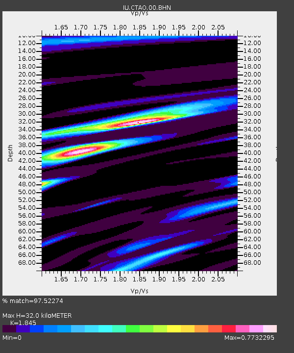
CTAO Charters Towers, Australia - Earthquake Result Viewer
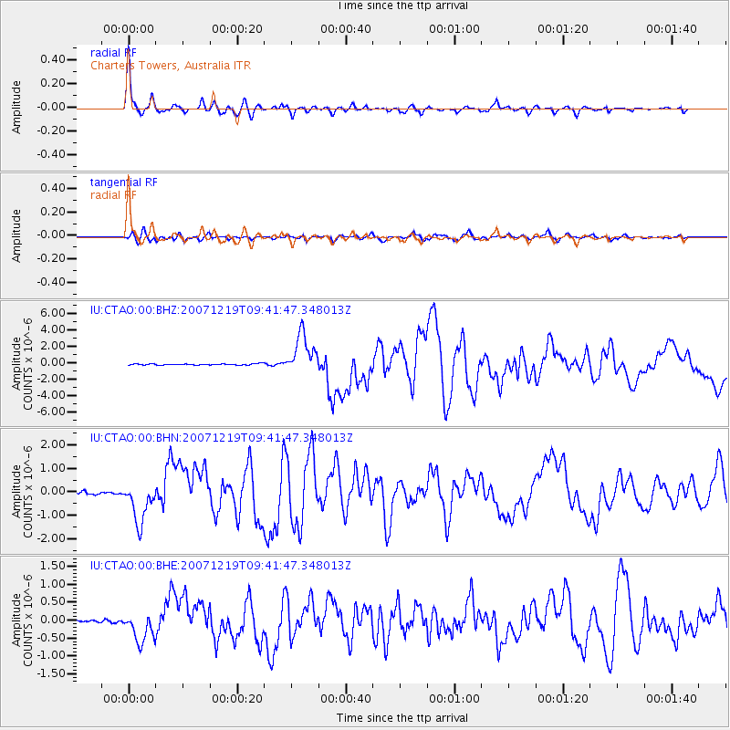
Earthquake location: Andreanof Islands, Aleutian Is.
Earthquake latitude/longitude: 51.4/-179.5
Earthquake time(UTC): 2007/12/19 (353) 09:30:27 GMT
Earthquake Depth: 29 km
Earthquake Magnitude: 6.4 MB, 7.1 MS, 7.1 MW, 7.0 MW
Earthquake Catalog/Contributor: WHDF/NEIC
Network: IU Global Seismograph Network (GSN - IRIS/USGS)
Station: CTAO Charters Towers, Australia
Lat/Lon: 20.09 S/146.25 E
Elevation: 357 m
Distance: 77.2 deg
Az: 212.824 deg
Baz: 21.196 deg
Ray Param: 0.050432533
Estimated Moho Depth: 32.0 km
Estimated Crust Vp/Vs: 1.85
Assumed Crust Vp: 6.522 km/s
Estimated Crust Vs: 3.535 km/s
Estimated Crust Poisson's Ratio: 0.29
Radial Match: 97.52274 %
Radial Bump: 337
Transverse Match: 87.42598 %
Transverse Bump: 400
SOD ConfigId: 2564
Insert Time: 2010-03-03 14:24:55.265 +0000
GWidth: 2.5
Max Bumps: 400
Tol: 0.001

Signal To Noise

ChannelStoNSTALTA
IU:CTAO:00:BHN:20071219T09:41:47.348013Z16.9282828.9224346E-75.2707268E-8
IU:CTAO:00:BHE:20071219T09:41:47.348013Z5.71217354.1607294E-77.283968E-8
IU:CTAO:00:BHZ:20071219T09:41:47.348013Z32.782452.465619E-67.5211545E-8
Arrivals
Ps4.3 SECOND
PpPs14 SECOND
PsPs/PpSs18 SECOND